Senneterre, Quebec (parish)
Senneterre | |
|---|---|
 | |
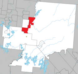
 Location within La Vallée-de-l'Or RCM | |
| Coordinates: 48°23′N 77°15′W / 48.383°N 77.250°W[1] | |
| Country | Canada |
| Province | Quebec |
| Region | Abitibi-Témiscamingue |
| RCM | La Vallée-de-l'Or |
| Settled | 1910s |
| Constituted | March 23, 1923 |
| Government | |
| • Mayor | Jacline Rouleau |
| • Federal riding | Abitibi—Baie-James— Nunavik—Eeyou |
| • Prov. riding | Abitibi-Est |
| Area | |
| • Total | 630.08 km2 (243.28 sq mi) |
| • Land | 567.05 km2 (218.94 sq mi) |
| Elevation | 301 m (988 ft) |
| Population (2021)[3] | |
| • Total | 1,202 |
| • Density | 2.1/km2 (5/sq mi) |
| • Pop (2016-21) | |
| • Dwellings | 606 |
| Time zone | UTC−5 (EST) |
| • Summer (DST) | UTC−4 (EDT) |
| Postal code(s) | |
| Area code | 819 |
| Highways | |
| Website | www |
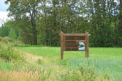
Senneterre is a parish municipality in northwestern Quebec, Canada, in the La Vallée-de-l'Or Regional County Municipality. The parish is mostly a rural municipality that almost completely surrounds the actual population centre of the neighbouring City of Senneterre.
The place is named after the geographic township of Senneterre, that in turn was named in honour of a captain of the Languedoc Regiment that fought under General Montcalm.[1]
History
[edit]In 1916, the geographic township was formed, and in 1923, the Township Municipality of Senneterre-Partie-Est was established out of the township's eastern part. In November 1931, it annexed the remainder of the geographic township (west and east of the Bell River), except for Senneterre-Partie-Ouest. It shortened its name and changed statutes to the Parish Municipality of Senneterre in 1949.[1][4]
In 1964 and 1969, the City of Senneterre annexed portions of its territory.[5]
Demographics
[edit]In the 2021 Census of Population conducted by Statistics Canada, Senneterre had a population of 1,202 living in 559 of its 606 total private dwellings, a change of 0.8% from its 2016 population of 1,192. With a land area of 567.05 km2 (218.94 sq mi), it had a population density of 2.1/km2 (5.5/sq mi) in 2021.[3]
| 2021 | 2016 | |
|---|---|---|
| Population | 1,202 (+0.8% from 2016) | 1,192 (-2.1% from 2011) |
| Land area | 567.05 km2 (218.94 sq mi) | 568.88 km2 (219.65 sq mi) |
| Population density | 2.1/km2 (5.4/sq mi) | 2.1/km2 (5.4/sq mi) |
| Median age | 55.2 (M: 55.6, F: 53.6) | 51.9 (M: 52.5, F: 51.2) |
| Private dwellings | 606 (total) 559 (occupied) | 563 (total) 539 (occupied) |
| Median household income | $74,500 | $67,226 |
|
|
| ||||||||||||||||||||||||||||||||||||||||||||||||||||||||||||
| Population counts are not adjusted for boundary changes. Source: Statistics Canada[5][10] | ||||||||||||||||||||||||||||||||||||||||||||||||||||||||||||||
Mother tongue (2021):[3]
- English as first language: 0.8 %
- French as first language: 97.9 %
- English and French as first language: 0.4 %
- Other as first language: 0.4 %
Local government
[edit]List of former mayors:[11]
- Julien Beauvais (1923–1930)
- Eugène Prévost (1931–1933, 1937–1940)
- Louis Major (1933–1936)
- Joseph Gagné (1941–1953)
- Édouard Duval (1953–1957)
- Azarie Paquin (1957–1958)
- Charles-Eugène Fortier (1959–1960)
- Gérard St-Pierre (1961–1963, 1966–1971)
- Gaston Beaudoin (1963–1965)
- Victor Leroux (1971–1975)
- Jean-Marie Chiasson (1975–1985)
- Louis-marie Martin (1985–1993)
- Pierre Patry (1993–1997)
- Raymond Bilodeau (1997–2005)
- Céliane Taillefer (2005–2009)
- Jacline Rouleau (2009–present)
References
[edit]- ^ a b c "Senneterre (Municipalité de paroisse)" (in French). Commission de toponymie du Québec. Retrieved 2011-01-13.
- ^ a b "Répertoire des municipalités: Geographic code 89045". www.mamh.gouv.qc.ca (in French). Ministère des Affaires municipales et de l'Habitation.
- ^ a b c d "Senneterre, Quebec (parish) (Code 2489045) Census Profile". 2021 census. Government of Canada - Statistics Canada.
- ^ "Historique de la municipalité". www.paroissesenneterre.qc.ca. Mun. de la Paroisse de Senneterre. Retrieved 14 November 2023.
- ^ a b 1971 Census of Canada : population, Volume I - part 1 Census subdivisions (historical). Ottawa: Statistics Canada. 1971. pp. 21, 127.
- ^ "2021 Community Profiles". 2021 Canadian census. Statistics Canada. February 4, 2022. Retrieved 2023-11-14.
- ^ "2016 Community Profiles". 2016 Canadian census. Statistics Canada. August 12, 2021. Retrieved 2023-11-14.
- ^ "2006 Community Profiles". 2006 Canadian census. Statistics Canada. August 20, 2019.
- ^ "2001 Community Profiles". 2001 Canadian census. Statistics Canada. July 18, 2021.
- ^ 1996, 2001, 2006, 2011 census
- ^ "Les maires depuis 1923". www.paroissesenneterre.qc.ca. Mun. de la Paroisse de Senneterre. Retrieved 14 November 2023.

