Shawnee, Colorado
Appearance
Shawnee, Colorado | |
|---|---|
| Country | |
| State | |
| County | Park CountyTemplate:GR |
| Government | |
| • Type | unincorporated town |
| Elevation | 2,475 m (8,120 ft) |
| Time zone | UTC-7 (MST) |
| • Summer (DST) | UTC-6 (MDT) |
| ZIP code[1] | 80475 |
| GNIS feature ID | 0183232 |
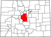
Shawnee is an unincorporated town and a U.S. Post Office located in northern Park County, Colorado, United States. Shawnee is situated in the Platte Canyon, along the North Fork South Platte River, west of Bailey on U.S. Highway 285. It consists largely of a general store and post office, and well as surrounding houses, on the hillside south of the highway overlooking the river valley. The Shawnee Post Office has the ZIP Code 80475.[1]
Geography
Shawnee is located at 39°25′12″N 105°33′06″W / 39.42000°N 105.55167°WInvalid arguments have been passed to the {{#coordinates:}} function (39.420017,-105.551662).
External links
References
- ^ a b "ZIP Code Lookup" (JavaScript/HTML). United States Postal Service. January 3 2007. Retrieved January 3 2007.
{{cite web}}: Check date values in:|accessdate=and|date=(help); Unknown parameter|dateformat=ignored (help)

