
Onstwedde
Onstwedde | |
|---|---|
 Nicolaas Church in 2008 | |
 Onstwedde Location of Onstwedde in the province of Groningen  Onstwedde Onstwedde (Netherlands) | |
| Coordinates: 53°2′7″N 7°2′28″E / 53.03528°N 7.04111°E | |
| Country | Netherlands |
| Province | Groningen |
| Municipality | Stadskanaal |
| Established | 875 |
| Area | |
| • Total | 40.57 km2 (15.66 sq mi) |
| Elevation | 5 m (16 ft) |
| Population (2021)[1] | |
| • Total | 2,960 |
| • Density | 73/km2 (190/sq mi) |
| Postal code | 9591 |
| Area code | 0599 |
| Website | www.onstwedde.info |
Onstwedde (Dutch pronunciation: [ɔnstˈʋɛdə]) is a village in the region of Westerwolde and part of Groningen in the Netherlands. It is located in the municipality of Stadskanaal.
Onstwedde was also the former name of the municipality of Stadskanaal, until 1969.[3]
History
[edit]Onstwedde was first mentioned in 875 as Uneswido in documents of the Werden Abbey.[4] The name means the forest (-wido similar to the English wood) of Une (first name).[5] The village is a double esdorp, a communal pasture surrounded by houses. The northern pasture was called Wold, and the southern pasture Loug.[6] Onstwedde was a part of Westerwolde, a region dominated by raised bogs which formed the natural border between Groningen, East Frisia and the Prince-Bishopric of Münster.[7][8] Onstwedde is located in the valley of the Mussel-Aa river,[6] and was a fertile island surrounded by bogs on all sides.[4]
A dominant feature of Onstwedde is the Nicolaas Church which was constructed around 1500. It has a 41 metres (135 ft) tall tower. The walls are 2 metres (6 ft 7 in) thick, and it used to be surrounded by a moat and could be accessed via a drawbridge. It is assumed that the church was also used as a fortification.[8]
Onstwedde used to be the main village of the region.[6] In 1765, the city of Groningen started to dig the Stadskanaal to the south of Onstwedde in order to exploit the peat.[9] In 1840, the population of Onstwedde was 2,405 people,[8] and Stadskanaal had 1,980 inhabitants.[9] Stadskanaal soon surpassed Onstwedde, and in 1882, the town hall was moved to Stadskanaal.[6] In 1969, the municipality was renamed Stadskanaal.[9]
On 20 April 1943, the Royal Canadian Air Force bomber Mosquito II crashed and burnt in Smeerling near Onstwedde. The crew members are buried in a Commonwealth War Grave on the municipal cemetery.[10]
Education
[edit]The two elementary schools of Onstwedde merged into a single entity. Since 2011, the kindergarten, elementary school and high school moved into MFA De Bast, a single building. Onstwedde is one of the few places in the Netherlands where all educational facilities are concentrated in a single building.[4]
Smeerling
[edit]
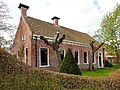
The hamlet of Smeerling is located on the road to Vlagtwedde.[11] It contains about ten houses and is home to approximately 25 people, and is considered a part of Onstwedde for statistical and postal services.[12]
There are eight farms in the hamlet which are in similar condition to the 1830 situation.[13] Five of the farms are monuments,[12] the others are from a later date, but traditionally constructed and match the surroundings. In 1972, the entire hamlet was designated a protected monument.[13] The protected area measures 91.6 hectares (226 acres). A two kilometre path has been constructed through the hamlet, forests and meadows of Smeerling.[12]
Notable people
[edit]- Henk Bleker (born 1953), Dutch politician[14]
- Izaak Reijnders (1879–1966), Dutch general[15]
Gallery
[edit]-
 Former town hall
 -
 Post mill (1936)
 -
 Pagediep, a remnant of the former bogs


References
[edit]- ^ a b "Kerncijfers wijken en buurten 2021". Central Bureau Statistics. Retrieved 26 February 2022.
- ^ "Postcodetool for 9591AA". Actueel Hoogtebestand Nederland (in Dutch). Het Waterschapshuis. Retrieved 26 February 2022.
- ^ Ad van der Meer and Onno Boonstra, Repertorium van Nederlandse gemeenten, KNAW, 2011.
- ^ a b c "Onstwedde - Het dorp". Onstwedde (in Dutch). Retrieved 26 February 2022.
- ^ "Onstwedde - (geografische naam)". Etymologie Bank (in Dutch). Retrieved 26 February 2022.
- ^ a b c d Redmer Alma (1998). "Onstwedde". Zwolle: Waanders Uitgevers. p. 180. ISBN 90 400 9258 3.
- ^ Bosgra, W.H. (1930). Uit Pekela's verleden (in Dutch). Oude Pekela: Feringa. pp. 9–11. Retrieved 26 February 2022.
- ^ a b c "Onstwedde". Plaatsengids (in Dutch). Retrieved 26 February 2022.
- ^ a b c "Stadskanaal". Plaatsengids (in Dutch). Retrieved 26 February 2022.
- ^ "Commonwealth War Graves Municipal Cemetery". Traces of War. Retrieved 26 February 2022.
- ^ G. Herwig; R.H. Herwig (1907). Geïllustreerde gids voor Westerwolde. Unknown. p. 6.
- ^ a b c "Smeerling". Plaatsengids (in Dutch). Retrieved 1 March 2022.
- ^ a b "Smeerling" (PDF). Rijksdienst voor het Cultureel Erfgoed (in Dutch). 11 September 1972. Retrieved 1 March 2022.
- ^ "Dr. H. (Henk) Bleker". Dutch Parliament (in Dutch). Retrieved 26 February 2022.
- ^ "Reijnders, Izaak Herman (1879-1966)". Huygens Institute for the History of the Netherlands (in Dutch). 2013. Retrieved 26 February 2022.
External links
[edit]- www.onstwedde.info (in Dutch)