Sorigny
Appearance
Sorigny | |
|---|---|
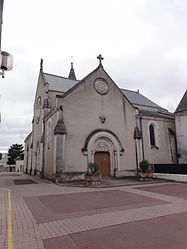
 The church of Saint-Pierre-ès-Liens, in Sorigny | |
| Coordinates: 47°14′33″N 0°41′46″E / 47.2425°N 0.6961°E | |
| Country | France |
| Region | Centre-Val de Loire |
| Department | Indre-et-Loire |
| Arrondissement | Tours |
| Canton | Monts |
| Government | |
| • Mayor (2008–2014) | Alain Esnault |
| Area 1 | 43.43 km2 (16.77 sq mi) |
| Population (2009) | 2,145 |
| • Density | 49/km2 (130/sq mi) |
| Time zone | UTC+01:00 (CET) |
| • Summer (DST) | UTC+02:00 (CEST) |
| INSEE/Postal code | 37250 /37250 |
| Elevation | 68–123 m (223–404 ft) |
| 1 French Land Register data, which excludes lakes, ponds, glaciers > 1 km2 (0.386 sq mi or 247 acres) and river estuaries. | |
Sorigny is a commune in the Indre-et-Loire department in central France.
Population
| Year | Pop. | ±% |
|---|---|---|
| 1793 | 1,350 | — |
| 1800 | 1,241 | −8.1% |
| 1806 | 1,366 | +10.1% |
| 1821 | 1,428 | +4.5% |
| 1831 | 1,564 | +9.5% |
| 1836 | 1,617 | +3.4% |
| 1841 | 1,513 | −6.4% |
| 1846 | 1,602 | +5.9% |
| 1851 | 1,507 | −5.9% |
| 1856 | 1,462 | −3.0% |
| 1861 | 1,403 | −4.0% |
| 1866 | 1,340 | −4.5% |
| 1872 | 1,271 | −5.1% |
| 1876 | 1,226 | −3.5% |
| 1881 | 1,125 | −8.2% |
| 1886 | 1,077 | −4.3% |
| 1891 | 1,142 | +6.0% |
| 1896 | 1,080 | −5.4% |
| 1901 | 1,067 | −1.2% |
| 1906 | 1,090 | +2.2% |
| 1911 | 1,077 | −1.2% |
| 1921 | 994 | −7.7% |
| 1926 | 1,072 | +7.8% |
| 1931 | 1,084 | +1.1% |
| 1936 | 1,105 | +1.9% |
| 1946 | 1,168 | +5.7% |
| 1954 | 1,227 | +5.1% |
| 1962 | 1,178 | −4.0% |
| 1968 | 1,256 | +6.6% |
| 1975 | 1,313 | +4.5% |
| 1982 | 1,520 | +15.8% |
| 1990 | 1,637 | +7.7% |
| 1999 | 1,923 | +17.5% |
| 2006 | 2,091 | +8.7% |
| 2009 | 2,145 | +2.6% |
See also
- Communes of the Indre-et-Loire department
- Marcel Gaumont. Sculptor of war memorial
References
Wikimedia Commons has media related to Sorigny.


