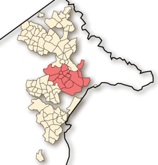
South Canberra

South Canberra or the Inner South is a central district of Canberra, the capital city of Australia.
South Canberra is located to the south of Canberra's city centre, on the south bank of Lake Burley Griffin.
It is one of the oldest parts of Canberra, and is built in part in accordance to Walter Burley Griffin's designs. Unlike the later districts in Canberra that are built as separate satellite cities, South Canberra is only separated from North Canberra by Lake Burley Griffin. The two districts combined form the district of Central Canberra and share Civic as their central commercial area.
According to the 2006 Census, South Canberra's population was 23,668.[1]
Places of note
- Australia's Parliament House on Capital Hill.
- Parkes contains the Parliamentary Triangle area.
- Government House the official residence of the governor general.
Sites of significance
In 1984 the National Capital Development Commission commissioned the identification and documentation of sites of significance in the ACT. The results for Inner Canberra were published in 1988. Sites with both natural and cultural significance were identified. Many of these are listed on the ACT Heritage Register.
Cultural sites of significance:
- Barton: Old Parliament House; Patent Offices (now the Sir Robert Garran Offices housing the Attorney-General's Department); Brassey House; Barton urban conservation area
- Deakin: The Lodge
- Kingston: Kingston shops (Eastlake Shopping Centre); Kingston Power House; Federal Capital Commission houses
- Forrest: Forrest urban conservation area; Street sign; Forrest residences
- Manuka: Housing group; St Christopher's school and convent; Manuka swimming pool; Manuka oval - curator's residence
- Red Hill: House 67, Arthur Circle; Calthorpes' House
- Yarralumla: Bus shelter: Schlich Street (destroyed by fire since identification); Surveyors hut; Albert Hall; Hotel Canberra; Australian Forestry School; Old Canberra Brickworks; Canberra Incinerator; Westbourne Woods; Government House
Natural sites of significance:
- Deakin anticlines
- Rutidosis leptorrhynchoides habitats
- State Circle road cutting
- Red Hill geological site
- Narrabundah Tors
- Hindmarsh Drive road cuttings
References
External links
- Canberra region map - all districts
