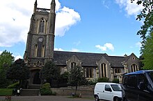
St John the Baptist's Church, Leytonstone
Appearance
This article includes a list of general references, but it lacks sufficient corresponding inline citations. (May 2017) |

St. John The Baptist's is a church in the centre of Leytonstone,[1] at the junction of the High Road and Church Lane. St. John's is part of the Church of England, the Diocese of Chelmsford and the Deanery of Waltham Forest.
The church is Grade II listed. [2]
Reverend David Britton took up the post of vicar in July 2014.[3]
History
The church was built in 1833 on land donated by William Cotton, Governor of The Bank of England and a well known philanthropist. The church was positioned on a raised platform so that it was visible over the fields that surrounded it and soon became the focal point for the emerging parish.
Events
- The Stones Throw Market, where stallholders offer a mix of local designs including jewellery, pottery, glassware, vintage clothing and homemade cakes and tea.[4]
- Churchyard Market
- Hitchcock outdoor film screenings in churchyard[5]
- Tower Tours, views across London to Canary Wharf, The Shard, Gherkin etc from the top of St John The Baptist's church tower.[6]
- Repair Cafe, a Waltham Forest Council scheme, offering free repairs of bikes and electrical items.[7]
References
- ^ "The Church Of England".
{{cite web}}: Cite has empty unknown parameter:|dead-url=(help) - ^ "British Listed Buildings".
{{cite web}}: Cite has empty unknown parameter:|dead-url=(help) - ^ "This Is Local London".
{{cite web}}: Cite has empty unknown parameter:|dead-url=(help) - ^ https://www.leytonstoner.london/2015/03/26/must-stones-throw-market/
- ^ http://www.guardian-series.co.uk/news/13440286.Alfred_Hitchcock__returns_home__in_sell_out_graveyard_screening/
- ^ http://www.victorianweb.org/art/architecture/blore/4.html
- ^ "Waltham Forest Council".
{{cite web}}: Cite has empty unknown parameter:|dead-url=(help)
External links
- St John The Baptist's Church, Leytonstone - official site
