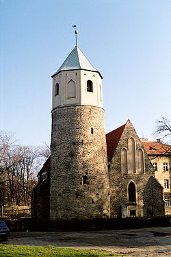
Strzelin
Strzelin | |
|---|---|
 | |
| Country | |
| Voivodeship | Lower Silesian |
| County | Strzelin County |
| Gmina | Gmina Strzelin |
| Government | |
| • Mayor | Dorota Pawnuk-Sznajder |
| Area | |
• Total | 10.34 km2 (3.99 sq mi) |
| Population (2006) | |
• Total | 12,192 |
| • Density | 1,200/km2 (3,100/sq mi) |
| Time zone | UTC+1 (CET) |
| • Summer (DST) | UTC+2 (CEST) |
| Postal code | 57-100 |
| Car plates | DST |
| Website | http://www.strzelin.pl |
Strzelin [ˈstʂɛlʲin] (Template:Lang-de, Template:Lang-cz) is a town in Lower Silesian Voivodeship in south-western Poland. It is located on the Oława river, a tributary of the Oder, about 39 kilometres (24 miles) south of the region's capital Wrocław. The town is the seat of Strzelin County and also of the smaller municipality (gmina) of Strzelin. It is known for its extensive granite quarries.
History
Prior to 1945 Strzelin was part of the Prussian Province of Lower Silesia. It was severely damaged in the course of the Lower Silesian Offensive of the Red Army against the Wehrmacht in February 1945. After World War II the region was placed under Polish administration and ethnically cleansed according to the post-war Potsdam Agreement. The native German populace was expelled and replaced with Poles. (For more information about the history of the region, see Silesia.)
As at 2013, the town has a population of 22,114.
Notable people
- Paul Ehrlich (1854-1915), physician
- Johann von Ravenstein (1889–1962), Wehrmacht general
- Błażej Augustyn, footballer, born 1988
International relations
Twin towns — Sister cities
Strzelin is twinned with:
External links
- Official town homepage Template:Pl icon
- TelewizjaStrzelin, a local TV station
- strzelin.net, a local news site
- Jewish Community in Strzelin on Virtual Shtetl
- PTTK Strzelin
- local newspaper "Strzeliński Ekspress Ogłoszeniowy" which alone has in his title coat of arms ,official
50°47′N 17°04′E / 50.783°N 17.067°E


