Styr
Appearance
| Styr | |
|---|---|
 | |
| Native name | Стир / Стыр Error {{native name checker}}: parameter value is malformed (help) |
| Physical characteristics | |
| Source | |
| • location | Lviv Oblast, Ukraine |
| Mouth | |
• location | Pripyat River |
| Length | 494 km (307 mi) |
| Basin size | 13,100 km2 (5,100 sq mi) |
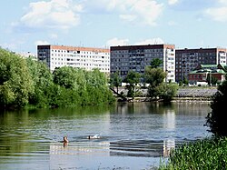
The Styr River (Ukrainian: Стир; Belarusian: Стыр; Russian: Стырь) is right tributary of the Pripyat River, with a length of 494 km. Its basin area is 13,100 km2.
The Styr River begins near Brody, in the Ukrainian Oblast of Lviv, then flows into the Rivne Oblast, Volyn Oblast, then into the Belarusian voblast of Brest where it finally flows into the Pripyat.
During 1915–1916, the Styr river was the front line between the Austro-Hungarian and Imperial Russian armies.
Notable settlements located on the river are Lutsk, Staryi Chortoryisk and Varash.
Wikimedia Commons has media related to Styr River.

