Sub-Cambrian peneplain

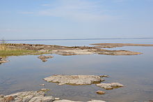
The sub-Cambrian peneplain is a geomorphic unit covering large swathes of Fennoscandia. It consists in a series of discontiguous low relief zones that are at some locations covered by a sedimentary rock cover dating to the Cambrian. Close to the cover rocks the exposed parts of the peneplain are extraordinarily flat.[1] The peneplain continues as an unconformity beneath the East European Platform.[2] In Norway the peneplain is apparently disrupted by vertical displacement along faults, following an NNE-SSW orientation.[3] Along the southern and central coast of Norrland in Sweden the peneplain is estimated to have been uplifted about 650 meters giving origin to a series of water gaps including those of Ångermanälven, Indalsälven and Ljusnan.[4]
The island Blå Jungfrun in the Baltic Sea is an ancient inselberg rising from the Sub-Cambrian peneplain. Being a inselberg formed in Precambrian time it was buried in sandstone after its formation and remained buried until erosion freed it in geologicaly recent times.[5]
See also
References
- ^ Lidmar-Bergström, Karna; Bonow, Johan M.; Japsen, Peter (2013). "Stratigraphic Landscape Analysis and geomorphological paradigms: Scandinavia as an example of Phanerozoic uplift and subsidence". Global and Planetary Change. 100: 153–171.
{{cite journal}}:|access-date=requires|url=(help) - ^ Det subkambriske peneplanet i Baltika
- ^ Jarsve, Erlend M.; Krøgli, Svein Olav; Etzelmüller, Bernd; Gabrielsen, Roy H. (2014). "Automatic identification of topographic surfaces related to the sub-Cambrian peneplain (SCP) in southern Norway—Surface generation algorithms and implications". Geomorphology. 211. Elsevier: 89–99.
{{cite journal}}:|access-date=requires|url=(help) - ^ Lidmar-Bergström, Karna; Olvmo, Mats (2015). Plains, steps, hilly relief and valleys in northern Sweden – review, interpretations and implications for conclusions on Phanerozoic tectonics (PDF) (Report). Geological Survey of Sweden. Retrieved June 29, 2016.
- ^ Lidmar-Bergström, Karna. "Inselberg". Nationalencyklopedin (in Swedish). Cydonia Development. Retrieved June 22, 2015.
