TDRS-3
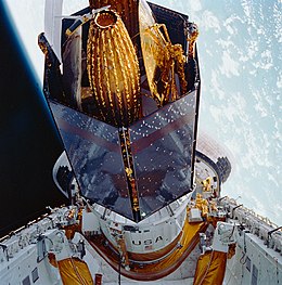
 TDRS-C aboard Discovery | |
| Mission type | Communication |
|---|---|
| Operator | NASA |
| COSPAR ID | 1988-091B |
| SATCAT no. | 19548[1] |
| Website | http://tdrs.gsfc.nasa.gov/ |
| Mission duration | 10 years (planned) 20+ years (achieved) |
| Spacecraft properties | |
| Manufacturer | TRW |
| Launch mass | 3,180 kilograms (7,010 lb)[2] |
| Start of mission | |
| Launch date | September 29, 1988, 15:37:00 UTC |
| Rocket | Space Shuttle Discovery STS-26 / IUS |
| Launch site | Kennedy LC-39B |
| Orbital parameters | |
| Reference system | Geocentric |
| Regime | Geostationary |
| Longitude | 151° West (1988) 171° West (1988-1990) 174° West (1990-1991) 62° West (1991-1994) 171° West (1994-1995) 85° East (1995—2009) 49° West (2009-) |
| Eccentricity | 0.001 |
| Perigee altitude | 35,693 kilometers (22,179 mi) |
| Apogee altitude | 35,878 kilometers (22,294 mi) |
| Inclination | 0° (BOL) 11.53 degrees (Current) |
| Period | 1,434.8 minutes |
| Epoch | 29 September 1988, 11:37:00 UTC[3] |
TDRS-3 , known before launch as TDRS-C, is an American communications satellite which is operated by NASA as part of the Tracking and Data Relay Satellite System. It was constructed by TRW, and is based on a custom satellite bus which was used for all seven first generation TDRS satellites.[4]
History

The TDRS-C satellite was launched aboard Space Shuttle Discovery during the STS-26 mission in 1988; the first Shuttle flight since the Challenger accident which had resulted in the loss of the previous TDRS satellite, TDRS-B. Discovery launched from Launch Complex 39B at the Kennedy Space Center at 15:37:00 GMT on September 29, 1988.[5] TDRS-C was deployed from Discovery around six hours after launch, and was raised to geostationary orbit by means of an Inertial Upper Stage.[5]
Deployment
The two-stage solid-propellent Inertial Upper Stage made two burns. The first stage burn occurred shortly after deployment from Discovery, and placed the satellite into a geosynchronous transfer orbit. At 04:30 on September 30, it reached apogee, and the second stage fired, placing TDRS-C into geosynchronous orbit. At this point it received its operational designation. Although the TDRS-2 designation had not been assigned, TDRS-C was given the designation TDRS-3 as NASA did not want to reuse the designation which had been intended for the STS-51-L payload.[6] It was briefly placed at a longitude 151° West of the Greenwich Meridian, before being moved to 171° West before the end of 1988, from where it provided communications services to spacecraft in Earth orbit, including Space Shuttles. In 1990, it was relocated to 174° West, and again in 1991 to 62° West. In 1994 it returned to 171° West.[7][8] In June 1995, it was moved to 85° East, from where it was used primarily for communications with spacecraft such as the Compton Gamma Ray Observatory and the Hubble Space Telescope.[7][9] In October 2009, as NASA began decommissioning TDRS-1, TDRS-3 was moved to 49° West,[10] where it remains in storage as of 2014.[11]
References
- ^ McDowell, Jonathan. "SATCAT". Jonathan's Space Pages. Retrieved 18 March 2014.
- ^ "UCS Satellite Database". Union of Concerned Scientists. 2009-07-01. Retrieved 2009-08-08.
- ^ "NASA - NSSDCA - Spacecraft - Trajectory Details". nssdc.gsfc.nasa.gov. Retrieved 2018-05-02.
- ^ Krebs, Gunter. "TDRS 1, 2, 3, 4, 5, 6". Gunter's Space Page. Retrieved 2009-08-08.
- ^ a b McDowell, Jonathan. "Launch Log". Jonathan's Space Page. Retrieved 2009-08-08.
- ^ "Designation". NASA'S Tracking and Data Relay Satellite. NASA. December 1992. Archived from the original on 2009-08-03.
{{cite web}}: Unknown parameter|deadurl=ignored (|url-status=suggested) (help) - ^ a b "TDRS 3". TSE. Retrieved 2009-08-08.
- ^ McDowell, Jonathan. "Index". Geostationary Orbit Catalog. Jonathan's Space Page. Retrieved 2009-08-08.
- ^ "The TDRS-J satellite". Spaceflight Now. 2002-12-01. Retrieved 2009-08-08.
- ^ Clark, Stephen (13 October 2009). "NASA retires 'queen' of tracking satellite fleet". Spaceflight Now. Retrieved 18 March 2014.
- ^ "Tracking and Data Relay Satellite (TDRS) Fleet". NASA. 11 February 2014. Retrieved 18 March 2014.

