Tadrart Rouge
| Tadrart Rouge | |
|---|---|
| تدرارت | |
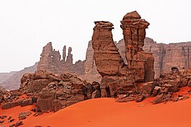
 View of the Tadrart Rouge near Djanet | |
| Highest point | |
| Elevation | 1,398 m (4,587 ft) |
| Coordinates | 23°40′17″N 10°53′26″E / 23.67139°N 10.89056°E[1] |
| Geography | |
SE Algeria | |
| Parent range | Tassili n'Ajjer |
The Tadrart Rouge (meaning "Red Tadrart") is a mountain range in southeastern Algeria.
Description
Tadrat Rouge is a roughly 100 km long southern prolongation of the Libyan Tadrart Acacus. It reaches its maximum elevation of 1,340 m towards the southern end of the range at about 160 km southeast of Djanet.
The Tadrart Rouge area is well known for the spectacular orange color of the sands contrasting with the jagged dark red rock formations of the range.[2][3]
See also
References
External links
 Media related to Tadrart Rouge at Wikimedia Commons
- La tadrart rouge. Algérie

