Taroudant
Taroudant
Tarudant / Rudana | |
|---|---|
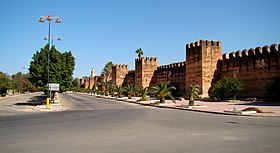
 Taroudant's defensive wall | |
| Country | |
| Region | Souss-Massa |
| Province | Taroudant |
| Elevation | 781 ft (238 m) |
| Population (2004) | |
| • Total | 63,000 |
| Time zone | UTC+0 (WET) |
| • Summer (DST) | UTC+1 (WEST) |
| Postal code | 83000 |
Taroudant (Berber: Tarudant, ⵜⴰⵔⵓⴷⴰⵏⵜ; Arabic: تارودانت) is a Moroccan city located in the Sous Valley in the southern part of the country. It is situated east of Agadir on the road to Ouarzazate and the Sahara desert and south of Marrakesh. It is called the "Grandmother of Marrakesh" because it looks like a smaller Marrakesh with its surrounding ramparts. In the sixteenth century the Saadians briefly used Taroudant as a capital, before they moved onwards to Marrakesh. Today it has the feel of a small fortified market town on a caravan route.
The city is known for its local crafts, including jewellery and carpets.
Unlike Marrakesh, almost the entire city of Taroudant is located inside its walls. A new part of the city is being developed outside the city walls around the campus of a faculty of the Ibn Zohr University of Agadir.
History
The town was occupied by the Almoravids in 1056.[1]
Under the Saadi Dynasty Taroudant had its golden age, particularly under the reign of Mohammed ash-Sheikh. He constructed the city walls and built the great mosque and its minaret in 1528. The town became the capital of the Saadians who used it as a base to attack the Portuguese in Agadir. Although they later made Marrakesh their capital, they made the town prosper through the riches of the Sous plain, marketing goods such as sugar cane, cotton, rice and indigo.[1]
A sad event was the massacre of its population by Moulay Ismail in 1687. Under the Alaouites the town resisted royal control. Citizens formed an alliance with Ahmed ibn Mahrez, a dissident nephew of Moulay Ismail.
Today the town is a notable market town and has a souk near each of its two main squares, Assarag and Talmoklate. There is also a weekly souk outside the city walls, near the future university district.[1]

The ramparts of the town are nearly 6 kilometres long and are set with bastions and punctuated by nine gates that still remain intact today.[1] Outside the ramparts is a small tannery mainly in the business of travel equipment for camel riding, such as goat skin, camel hide sandals, leather bags and belts.
The Berber market, called Jnane al-Jaami, sells spices and dried fruits but mostly clothes and household goods.[1] The Arab souk, however, specializes in handicrafts such as terracotta, wrought iron, pottery, brass and copper, leather and carpets, rugs and jewellery.[1]
