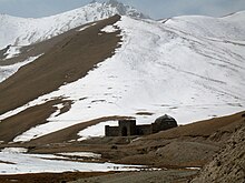
Tash Rabat
 Tash Rabat situated in the surrounding mountains | |
| Location | Naryn Province, Kyrgyzstan |
|---|---|
| Coordinates | 40°49′23″N 75°17′20″E / 40.82315°N 75.288766°E |
| Type | Caravanserai |
| History | |
| Founded | 15th century |
| Site notes | |
| Ownership | Tursun Zhutabaeva (caretaker) |
Tash Rabat is a well-preserved 15th century stone caravanserai in At Bashy district, Naryn Province, Kyrgyzstan located at an altitude of 3,200 meters.
Geography
Tash Rabat is located somewhat east of the main north-south highway. To the south is Lake Chatyr-Kul and Torugart Pass. To the north is Koshoy Korgon, a ruined fortress of uncertain date. The area is a center for hiking and horse-trekking. The caretakers of Tash Rabat offer lodging, consisting of 5 or 6 yurts.[citation needed]
Research
As early as 1888, Russian doctor and traveler Nicolay Lvovich Zeland suggested that it was originally a Nestorian or Buddhist monastery.[1] Research undertaken at the end of the 1970s and beginning of the 1980s by the Institute of History of the Kyrgyz Academy of Sciences concluded that Tash Rabat was originally built as a Nestorian monastery in the 10th century, although no Christians artifacts were found during excavations.[2]
Architecture
The structure consists of 31 rooms, including chambers in the central hall. The rooms are dome-shaped; transition from a quadrangular frame to a dome is done using a squinch. Tash Rabat is completely made of crushed stone on clay mortar with gypsum mortar sealing joints.[3]
References
- ^ Zeland, Nicolay (1888). Записки Западно-Сибирского отдела Императорского Русского Географического Общества. Книжка IX. Кашгария и перевалы Тянь-Шаня. Путевые заметки [Notes of the West Siberian division of the Imperial Russian Geographical Society. Book IX. Kashgaria and passes of Tien-Shan. Travel notes.] (in Russian). Omsk: Imperial Russian Geographical Society. p. 212.
- ^ Khudyakov, Ju. (2009). Таш Рабат - Караван-сарай или замок [Tash Rabat - caravanserai or temple.]. Priroda (in Russian) (6). Russian Academy of Sciences: 55. Retrieved 2 May 2014.
- ^ Иссык-Куль.Нарын:Энциклопедия [Encyclopedia of Issyk-Kul and Naryn Oblasts] (in Russian). Bishkek: Chief Editorial Board of Kyrgyz Soviet Encyclopedia. 1991. p. 512. ISBN 5-89750-009-6.

