
Three Nations Crossing
| Three Nations Crossing | |
|---|---|
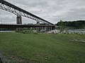
 The former Canadian Border Inspection Station on Cornwall Island | |
 Click on the map for a fullscreen view | |
| Location | |
| Country | United States; Canada |
| Location | US Port: 30M Seaway International Bridge, Rooseveltown, New York 13683 Canadian Port: 755 Brookdale Avenue, Cornwall, Ontario K6J 5C6 |
| Coordinates | 44°59′26″N 74°44′22″W / 44.990602°N 74.739561°W |
| Details | |
| Opened | 1935 |
| US Phone | (315) 769-3091 |
| Canadian Phone | (613) 932-5875 |
| Hours | Open 24 Hours |
| Statistics | |
| Website https://www.cbp.gov/contact/ports/massena | |
The Three Nations Crossing is a border crossing on the Canada–US border, connecting the city of Cornwall, Ontario in Canada to Rooseveltown, New York, a neighborhood within the Town of Massena, in the United States. The crossing is associated with the Seaway International Bridge, which crosses the two channels on each side of Cornwall Island, which is located in the St. Lawrence River; the bridge is 4.7 km (2.9 mi) in total length.
In 2000, the international border crossing was named the Three Nations Crossing, in honour of the Mohawk of Akwesasne, a federally recognized tribe in the United States and First Nation in Canada. Their reserve extends across the international border, in addition to that between Quebec and Ontario. Most of the land is in New York, United States.
On May 31, 2009, Akwesasne Mohawk occupied the area around the Canada Border Services Agency's (CBSA) port of entry building to protest the Canadian government's decision to arm these border agents by June 1, 2009, as they were operating on Mohawk sovereign land. At 11:45 p.m. on May 31, the border guards were ordered by the CBSA to leave the building, Canadian Customs was closed, and the north span of the bridge was closed.[1] Although American Customs remained opened for southbound traffic, northbound traffic was blocked on the American side by both American and Canadian officials. Over the following six weeks, the Canadian border officially remained closed. At 06:00 on July 13, CBSA opened a "temporary" border inspection station at the north end of the north span of the bridge in the city of Cornwall, effectively opening the bridge for all traffic in both directions.
The Akwesasne Mohawk continue to stage periodic protests which result in the temporary closure of the crossing. In 2014 they objected to a process that made their crossing more tedious; they feel it violates their treaty rights of free passage. When they travel from the US to their land on Cornwall Island, they must cross the second bridge into Canada, in order to report for inspection at the new Canadian border station, before they can return to Cornwall Island. Discussions are being pursued between government agencies about moving the Canadian border inspection facility to the US side of the border, but there are many questions associated with the effects on Canadian enforcement and prosecution if they were operating on US soil.[2]
A new North Channel Bridge between Cornwall and Akwesasne in Ontario, Canada, was completed in 2014. It replaced the Seaway International Bridge, which was demolished in July 2015.
-
 New North Channel Bridge between Cornwall and Akwesasne in Ontario, Canada
 -
 New 2014 Bridge between Cornwall and Akwesasne, Ontario, Canada. New bridge is lower bridge. Old bridge is higher bridge. It is scheduled to be removed.
 -
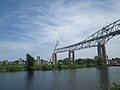 July 2015: Demolition of Seaway International Bridge, which was replaced by the much lower North Channel Bridge


See also
- List of Canada–United States border crossings
- List of crossings of the Saint Lawrence River
- Cornwall Island (Ontario)
References
- ^ "Mohawks Allow Some To Cross Bridge: Border Dispute Enters Second Week". Plattsburgh, New York: WPTZ. June 8, 2009. Retrieved April 15, 2011.
- ^ Sommerstein, David (Jan 24, 2014). "New Cornwall bridge opens, but it still feels closed to Mohawks". North Country Public Radio. Retrieved 13 November 2016.