
Tramways of the Salinas Chicas
| Tramways of the Salinas Chicas | |||
|---|---|---|---|
.jpg) | |||
| Technical | |||
| Line length | 22 km (14 mi) | ||
| Track gauge | 750 mm (2 ft 5+1⁄2 in) | ||
| |||
.jpg)
.jpg)
The Tramways of the Salinas Chicas were two 750 mm (2 ft 5+1⁄2 in) gauge railways with a total length of 22 km (14 mi). They ran from the Nicolás Levalle railway station(es) to the Salinas Chicas in the La Pampa Province between Neuquén und Bahía Blanca in Argentina.
History[edit]
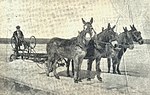
The salt flats were exploited by the company Salinas Chicas in La Aurora, founded in 1903 by Bernardo Garciarena, to mine a 1–3 centimetres (0.39–1.18 in) thick layer of salt, which was formed by the evaporation of seawater in a lagoon, which is now 42 metres (138 ft) below sea level.[1] The salt was initially pushed together with graders pulled by mules and transported to the railway station in tippers.[2]
In the beginning, animals were used to mine about 500 to 1000 tons of salt per year, and from 1910 steam locomotives manufactured by Orenstein & Koppel and Krauss (N° 5998/1908) were also used, with wagons made in Germany.[3] At this time, another company was founded nearby under the name of Salina Las Barrancas. From the 1950s, tractors were used to mine 50,000 to 200,000 tonnes of salt per year.
The operation of the tramway ceased in 1990. Today, La Aurora SAIC y G. extracts about 1000 tons of salt per day on an industrial scale, washes it, packages it mainly in 50 kg bags and sells it.[4]
-
 Building a 1 km (0.6 mi) long dam into the lagoon
 -
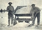
 Scraping the salt with a grader
 -
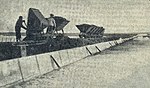
 Loading a V skip waggon
 -
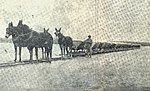
 Loading V skip waggons
 -
 Hauling a train by mules
.jpg)
.jpg)
.jpg)
.jpg)
.jpg)
External links[edit]
- www.salaurora.com.ar (official Website of La Aurora SAIC y G.)
- The 750mm gauge Krauss 0-6-0T (5998/1908) at “Salitrera La Aurora”, near Bahía Blanca
References[edit]
- ^ "Extraccion". La Aurora SAIC y G. Retrieved 5 September 2020.
- ^ José Manuel Fuentes: Nicolás Levalle (F.C. Sud) 2da. Parte : Las Salinas. Historia. 3 February 2014. Retrieved on 5 September 2020.
- ^ Rob Dickinson und Marcelo Benoit: Preserved Steam in Argentina Part 3.
- ^ Historia. On the official web site of La Aurora SAIC y G. Retrieved on 5 September 2020.