Tumaraa
Appearance
Tumara'a | |
|---|---|
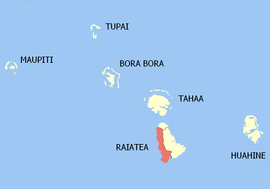
 Location of the commune (in red) within the Leeward Islands | |
| Coordinates: 16°47′00″S 151°29′00″W / 16.7833°S 151.4833°W | |
| Country | France |
| Overseas collectivity | French Polynesia |
| Subdivision | Leeward Islands |
| Government | |
| • Mayor (2020–2026) | Cyril Tetuanui[1] |
| Area 1 | 63.2 km2 (24.4 sq mi) |
| Population (2022)[2] | 3,718 |
| • Density | 59/km2 (150/sq mi) |
| Time zone | UTC−10:00 |
| INSEE/Postal code | 98754 /98735 |
| Elevation | 0–1,017 m (0–3,337 ft) |
| 1 French Land Register data, which excludes lakes, ponds, glaciers > 1 km2 (0.386 sq mi or 247 acres) and river estuaries. | |
Tumara'a is a commune of French Polynesia, an overseas territory of France in the Pacific Ocean. The commune of Tumara'a is located on the island of Ra'iātea, in the administrative subdivision of the Leeward Islands, themselves part of the Society Islands. At the 2022 census it had a population of 3,718, making it the least populous commune on Ra'iātea.[2]
Tumara'a consists of the following associated communes:
The administrative centre of the commune is the settlement of Tevaitoa. The tallest mountain on Ra'iātea - Mont Temehani - is located within Tumara'a.[3]
References
[edit]- ^ "Répertoire national des élus: les maires" (in French). data.gouv.fr, Plateforme ouverte des données publiques françaises. 13 September 2022.
- ^ a b "Les résultats du recensement de la population 2022 de Polynésie française" [Results of the 2022 population census of French Polynesia] (PDF) (in French). Institut de la statistique de la Polynésie française. January 2023.
- ^ "TUMARAA : présentation générale - SPCPF". spc.pf.
Wikimedia Commons has media related to Tumaraa.

