
Uetliberg railway station
Uetliberg | |||||||||||
|---|---|---|---|---|---|---|---|---|---|---|---|
 | |||||||||||
| General information | |||||||||||
| Location | Uetliberg, Stallikon, Canton of Zurich, Switzerland | ||||||||||
| Coordinates | 47°21′06″N 8°29′15″E / 47.3518°N 8.4876°E | ||||||||||
| Elevation | 813 m (2,667 ft) | ||||||||||
| Owned by | Sihltal Zürich Uetliberg Bahn | ||||||||||
| Operated by | Sihltal Zürich Uetliberg Bahn | ||||||||||
| Line(s) | Uetliberg line | ||||||||||
| Services | |||||||||||
| |||||||||||
Uetliberg is a railway station in Switzerland, situated near to the summit of the Uetliberg mountain. The station is the terminus of the Uetliberg line, which is operated by the Sihltal Zürich Uetliberg Bahn (SZU). It is located within the municipality of Stallikon, although the adjacent mountain-top is divided between Stallikon and the city of Zürich.[1][2][3]
The station dates back to 1875, when the Uetlibergbahn-Gesellschaft opened its line from Bahnhof Selnau in Zürich to the summit of the Uetliberg mountain. The line was electrified using the direct current system in 1923.[4]
The station is served by the following passenger trains:[5]
| Operator | Train Type | Route | Typical Frequency | Notes |
|---|---|---|---|---|
| SZU | Zürich S-Bahn S10 |
Zürich Hbf - Zürich Selnau - Zürich Binz - Zürich Friesenberg - Zürich Schweighof - Zürich Triemli - Uitikon Waldegg - Ringlikon - Uetliberg | 2-3 trains per hour |
The station lies some 650 m (2,130 ft) from, and 56 m (184 ft) below, the summit of the Uetliberg, to which it is linked by a footpath. It has two terminal tracks, and a substantial station building, including a restaurant.[3]
Gallery
-
 The station in 1925, with both steam and electric trains
 -
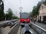
 Train approaching the station
 -
 View from the end of the station platform, looking north
 -
 View from the end of the station platform, looking west


References
- ^ Zurich City Map (Map). 1:16000. Hallwag Kümmerlry+Frey AG. 2009-01-25. ISBN 978-3-8283-0070-5.
- ^ "Bahn S4/S10" [Railway S4/S10] (in German). SZU. Retrieved 2011-09-01.
- ^ a b Eisenbahnatlas Schweiz. Verlag Schweers + Wall GmbH. 2012. pp. 64–65. ISBN 978-3-89494-130-7.
- ^ "Geschichte der Uetlibergbahn" [History of the Uetlibergbahn] (PDF) (in German). SZU. Archived from the original (PDF) on 2012-03-31. Retrieved 2011-09-05.
{{cite web}}: Unknown parameter|deadurl=ignored (|url-status=suggested) (help) - ^ "Zürich HB–Triemli–Uetliberg" (PDF). Bundesamt für Verkehr. Retrieved 2013-03-21.
External links
 Media related to Uetliberg railway station at Wikimedia Commons