
Union Cross, North Carolina
Union Cross, North Carolina | |
|---|---|
 Union Cross  Union Cross | |
| Coordinates: 36°02′54″N 80°07′08″W / 36.04833°N 80.11889°W | |
| Country | United States |
| State | North Carolina |
| County | Forsyth |
| Elevation | 978 ft (298 m) |
| Time zone | UTC-5 (Eastern (EST)) |
| • Summer (DST) | UTC-4 (EDT) |
| ZIP code | 27284 |
| Area code | 336 |
| FIPS code | 37-37067 |
| GNIS feature ID | 1023037[1] |
| [2] | |
Union Cross is an unincorporated community in southeastern Forsyth County, North Carolina, United States. Parts of the community have been annexed by Kernersville and Winston-Salem as a result of the area's large population growth and the construction of the new Dell plant. The community holds Union Cross Traditional Academy, as well as Glenn High School.
Geography
Union Cross is located at 36°02′54″N 80°07′07″W / 36.04833°N 80.11861°W (36.048470 -80.118933).[1] It is located southeast of Winston-Salem at the intersection of High Point Road, and Union Cross Road, north of U.S. Route 311, and Future Interstate 74. Its elevation is 978 feet (298 m).[1]
References
- ^ a b c d U.S. Geological Survey Geographic Names Information System: Union Cross, North Carolina. Retrieved on 2008-05-04.
- ^ "Union Cross NC". ZIP Code Lookup. Retrieved 2008-06-09.
Municipalities and communities of Forsyth County, North Carolina, United States | ||
|---|---|---|
| Cities | 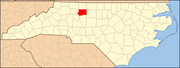 | |
| Towns | ||
| Villages | ||
| Townships | ||
| CDP | ||
| Unincorporated communities | ||
| Footnotes | ‡This populated place also has portions in an adjacent county or counties | |