
University Bridge (Seattle)
University Bridge | |
|---|---|
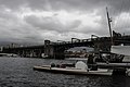
 University Bridge from the west; part of the Ship Canal Bridge is visible in the top right corner | |
| Coordinates | 47°39′11″N 122°19′12″W / 47.6531°N 122.32°W |
| Carries | Eastlake Avenue |
| Crosses | Portage Bay |
| Locale | Seattle, Washington |
| Characteristics | |
| Design | Bascule bridge |
| Longest span | 66 m (217 ft)[citation needed] |
| History | |
| Opened | 1919 |
University Bridge | |
| Location | Spans Lake Washington Ship Canal, Seattle, Washington |
| Coordinates | 47°39′11.1″N 122°19′12.4″W / 47.653083°N 122.320111°W |
| Built | 1915–1919 |
| MPS | Historic Bridges/Tunnels in Washington State TR |
| NRHP reference No. | 82004254[1] |
| Added to NRHP | July 16, 1982 |
| Location | |
 | |
The University Bridge is a double-leaf bascule bridge in Seattle, Washington that carries Eastlake Avenue traffic over Portage Bay between Eastlake to the south and the University District to the north. Built in 1919, it has an opening span of 66 meters (217 feet). The bridge was remodeled in 1933 and was dedicated by President Franklin D. Roosevelt. It was added to the National Register of Historic Places in 1982.
Sinkhole
On May 2, 2007, a 24-inch (61 cm) water main broke near the south end of the University Bridge, creating a 10-foot-deep (3.0 m) sinkhole forcing the closure of the bridge.[2] The sinkhole also swallowed two unoccupied parked cars. The water main break compromised water quality and pressure in a large part of the Eastlake neighborhood, making tap water brown and unpotable. Many restaurants and other businesses were forced to close. There was concern for the integrity of a 40-inch main adjacent to the smaller one that broke. With the bridge closed, surface traffic between Seattle's University District and Downtown areas was heavily impacted. It was reopened on May 3, 2007, after city workers poured about 40 cubic yards of stabilizing concrete-sand slurry around the southern base of the bridge.[3]
Occupy Seattle
On November 17, 2011, the University Bridge was shut down by demonstrators for about an hour and a half during the evening rush hour, snarling traffic around the University District. The demonstrators included Occupy Seattle protesters, students, union workers, and church leaders. The protests were part of a national Day of Action against cuts to infrastructure, health care, and education spending.[4]
Pictures
-
 The bridge viewed from the east, with Ship Canal Bridge in the background.
 -
 The bridge at sunset, viewed from the west
 -
 View from the south end
 -
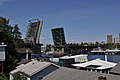 Bridge while open


References
- ^ "National Register Information System". National Register of Historic Places. National Park Service. July 9, 2010.
- ^ Massive sinkhole swallows cars, shuts down water service in Eastlake, Seattle P-I, May 2, 2007, retrieved 2009-03-21
- ^ U. Bridge open again after repairs, Seattle Times, May 3, 2007, retrieved 2009-03-21
- ^ Mike Lindblom (November 17, 2011). "University Bridge seized in rush-hour rally for jobs". Seattle Times. Retrieved 2011-12-30.
External links
- 1919 establishments in Washington (state)
- Bascule bridges in the United States
- Bridges in Seattle
- Bridges completed in 1919
- Drawbridges on the National Register of Historic Places
- National Register of Historic Places in Seattle
- Road bridges in Washington (state)
- Road bridges on the National Register of Historic Places in Washington (state)