
Unter den Linden

Unter den Linden ("under the linden trees") is a boulevard in the Mitte district of Berlin, the capital of Germany. It is named for its linden (lime in British English) trees that line the grassed pedestrian mall between two carriageways.
Unter den Linden runs east–west from the site of the former Stadtschloss royal palace at the Lustgarten park, where the demolished Palast der Republik used to be, to Pariser Platz and Brandenburg Gate. Eastward the boulevard crosses the Spree river at Berlin Cathedral and continues as Karl-Liebknecht-Straße. The western continuation behind Brandenburg Gate is Straße des 17. Juni. Major north–south streets crossing Unter den Linden are Friedrichstraße and Wilhelmstrasse.

Unter den Linden at the heart of the historic section of Berlin developed from a bridle path laid out by Elector John George of Brandenburg in the 16th century to reach his hunting grounds in the Tiergarten. It was replaced by a boulevard of linden trees planted in 1647, extending from the city palace to the gates of the city, by order of the “Great Elector” Frederick William. While the western part of the boulevard retained its character, the area around present-day Bebelplatz was integrated into the fortification of Berlin in the aftermath of the Thirty Years' War, visible until today as there are no trees.
By the 19th century, as Berlin grew and expanded to the west, Unter den Linden became the best-known and grandest street in Berlin. In 1851 the famous equestrian statue of King Frederick II of Prussia was erected on the centre strip, designed by Christian Daniel Rauch. In the course of the building of the Nord-Süd-Tunnel for the Berlin S-Bahn in 1934–35, most of the linden trees were cut down and during the last days of World War II the remaining trees were destroyed or cut down for firewood. The present-day linden were replanted in the 1950s;[citation needed] they are affected by air pollution as well as by soil contamination.
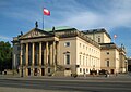
Points of interest

Since 1937, the numbering[clarification needed] has started at the Schlossbrücke (Palace Bridge), connecting Unter den Linden with the Lustgarten and Museum Island. The disputed replica of the Alte Kommandantur is No. 1, vis-à-vis the Zeughaus arsenal, the oldest building on Unter den Linden, built between 1695 and 1706, today the seat of the Deutsches Historisches Museum (No. 2). Buildings along the street include (from east to west) the Kronprinzenpalais (former palace of the Hohenzollern crown princes, No. 3), the Neue Wache war memorial built in 1817 (No. 4), considered by many[who?] to be Karl Friedrich Schinkel’s masterpiece. Furthermore on Bebelplatz the Berlin State Opera (No. 7), colloquially called Lindenoper, St. Hedwig's Cathedral and the Altes Palais (No. 9), favoured residence of Emperor Wilhelm I; in the north the main building of the Humboldt University (No. 6) and House I of the Berlin State Library (No. 8). On the western end are the Russian Embassy (former Soviet Embassy, No. 63-65) the Hungarian Embassy (No. 76) at the corner of Wilhelmstrasse and finally the Hotel Adlon (No. 77) at the corner of Pariser Platz, which has been completely rebuilt on the site of the prewar hotel. Well-known statues of Alexander and Wilhelm von Humboldt in front of the university as well as of the Prussian generals Scharnhorst and Bülow also adorn the street. The street sign that dates from before the 1930s can be found at the Imperial War Museum, London.
Along Unter den Linden
-
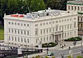
 Aerial view of Unter den Linden from Berlin Cathedral to Brandenburg Gate
 -
 At night
 -
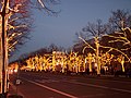 Christmas illumination
 -
 Eastern end at Schlossbrücke (Palace Bridge)
 -
-
-
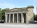 Neue Wache (New Guard House) memorial
 -
-
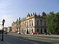
 Main building of Humboldt University
 -
 Equestrian statue of King Frederick II of Prussia, facing east
 -

-
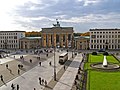 Brandenburg Gate at Pariser Platz, which marks the western terminus


See also
- Berlin Brandenburger Tor station – formerly Berlin Unter den Linden
External links
- Unter den Linden - Interactive 360° Panorama
- Webcam: Live-View of the street Unter den Linden with Brandenburg Gate in Berlin, Germany