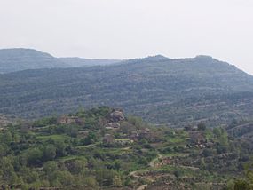
Used, Huesca
Appearance
42°19′25″N 0°11′31″W / 42.32361°N 0.19194°W
Used | |
|---|---|
Village | |
 Village of Used | |
 | |
| Country | Spain |
| Autonomous Community | Aragon |
| Province | Huesca |
| Comarca | Alto Gállego |
| Municipio | Sabiñánigo |
| Area | |
• Total | 10.8 km2 (4.2 sq mi) |
| Elevation | 1,150 m (3,770 ft) |
| Population (2006) | |
• Total | 1 |
| Time zone | UTC+1 (CET) |
| • Summer (DST) | UTC+2 (CEST) |
| Postal code | 22622 |
| Area code | 34 (Spain) + 974 (Huesca) |
Used (Template:Lang-an) is a village under the local government of the municipality of Sabiñánigo, Alto Gállego, Huesca, Aragon, Spain.
Located near the Sierra y Cañones de Guara natural park, the surrounding area is a very good place for speleology and sports like rock climbing and canyoning.
See also
References
This article needs additional citations for verification. (September 2007) |
External links
