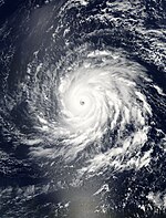
User:HurricaneSpin/Sandbox3
| |||
|---|---|---|---|
Current storm status Category 3 hurricane (1-min mean) | |||
| |||
| As of: | 2 p.m. AST (1800 UTC) September 17 | ||
| Location: | 23.4°N 60.7°W ± 15 nm About 665 mi (1070 km) SSE of Bermuda | ||
| Sustained winds: | 100 knots | 115 mph | 185 km/h (1-min mean) gusting to 125 knots | 145 mph | 230 km/h | ||
| Pressure: | 946 mbar (hPa) | 27.94 inHg | ||
| Movement: | NW at 8 kt | 9 mph | 15 km/h | ||
| See more detailed information. | |||
| Part of the 2013 Atlantic hurricane season |
Meteorological history[edit]

Map key
Tropical depression (≤38 mph, ≤62 km/h)
Tropical storm (39–73 mph, 63–118 km/h)
Category 1 (74–95 mph, 119–153 km/h)
Category 2 (96–110 mph, 154–177 km/h)
Category 3 (111–129 mph, 178–208 km/h)
Category 4 (130–156 mph, 209–251 km/h)
Category 5 (≥157 mph, ≥252 km/h)
Unknown
Tropical storm (39–73 mph, 63–118 km/h)
Category 1 (74–95 mph, 119–153 km/h)
Category 2 (96–110 mph, 154–177 km/h)
Category 3 (111–129 mph, 178–208 km/h)
Category 4 (130–156 mph, 209–251 km/h)
Category 5 (≥157 mph, ≥252 km/h)
Unknown
Storm type
Preparations and Impact[edit]
Records and Naming[edit]
See also[edit]
- 2013 Atlantic hurricane season
- Timeline of the 2013 Atlantic hurricane season
- List of tropical cyclone names
References[edit]
* The corresponding dates are in UTC
External links[edit]
Wikimedia Commons has media related to HurricaneSpin/Sandbox3.


