
User:Arjuno3/Sandbox
 | |
 | |
| UTC time | ?? |
|---|---|
| Magnitude | 7.5 Mw |
| Depth | 5 kilometres (3 mi) |
| Epicenter | 15°19′N 89°06′W / 15.32°N 89.10°W Motagua Fault |
| Areas affected | |
| Max. intensity | MM IX[1] |
| Casualties | 23,000 fatalities, 76,000 injured |
The 1976 Guatemala earthquake struck on February 4, 1976 at 03:01:43 local time (09:01:43 UTC-6). It was a 7.5 Mw earthquake, centered in the Motagua Fault, about 160 km northeast of Guatemala City, Guatemala. The quake's hypocenter was located at a depth of 5 km near the town of Los Amates in the department of Izabal.[1]
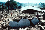
Cities throughout the country suffered damage, and most adobe type houses in the outlying areas of Guatemala City were completely destroyed. The earthquake struck during the early morning (at 3.01 am, local time) when most people were asleep. This has contributed to the high death toll of 23,000. Approximately 76,000 were injured, and many thousands left homeless. Some of areas went without electricity and communication for days.
The main shock was followed by thousands of aftershocks, some of the larger ones causing additional loss of life and damage.[2]
Seismic data[edit]
The quake's epicentre was located near the town of Los Amates, in the eastern part of the Motagua Fault, a left-lateral strike-slip fault that forms the tectonic boundary between the North American plate and the Caribbean plate.[1] Ground shaking was felt during approximately 39 seconds, and caused visible rupturing over 230 km along the Motagua fault, while the inferred length of faulting -based on aftershock registration- was estimated at 300 km. Average horizontal displacement along the Motagua fault was 100 cm, with a maximum displacement of 326 cm.[1]
Maximum seismic intensity (MM IX) was located in the Mixco area, some sections of Guatemala City and in Gualán. A seismic intensity of MM VI covered an area of 33,000 km2.[1] Liquefaction and sand boils were observed in several locations with high seismic intensity.
The main quake activated secondary fault zones, including the Mixco fault, located in a densely populated area just north-west of Guatemala City.
Aftershocks[edit]
Several heavy aftershocks, ranging from 5.2 to 5.8 Mw caused additional casualties and hampered relief efforts.
| Date | Origin Time | Coordinates | Location | Depth | Magnitude |
| Feb. 04 1976 | 09.30.28.3 | 14°42′N 90°36′W / 14.7°N 90.6°W | 7 km NNE of Mixco | 5 km | 5.8 Mw |
| Feb. 06 1976 | 04.11.03.3 | 14°36′N 91°06′W / 14.6°N 91.1°W | 6 km SSE of San Lucas Tolimán | 5 km | 4.8 Mw |
| Feb. 06 1976 | 18.11.59.2 | 14°18′N 90°12′W / 14.3°N 90.2°W | 11 km ENE of Cuilapa | 5 km | 5.2 Mw |
| Feb. 06 1976 | 18.19.17.7 | 14°42′N 90°36′W / 14.7°N 90.6°W | 5 km ENE of San Pedro Sacatepéquez | 5 km | 5.8 Mw |
| Feb. 08 1976 | 08.13.51.9 | 15°42′N 88°30′W / 15.7°N 88.5°W | 13 km SE of Puerto Barrios | 5 km | 5.7 Mw |
| Feb. 09 1976 | 11.44.46.7 | 15°18′N 89°06′W / 15.3°N 89.1°W | 30 km WSW of Morales | 5 km | 5.1 Mw |
| Feb. 10 1976 | 06.17.43.0 | 15°00′N 89°42′W / 15.0°N 89.7°W | 18 km WNW of Zacapa | 5 km | 4.7 Mw |
| Mar. 07 1976 | 02.54.05.4 | 14°54′N 90°54′W / 14.9°N 90.9°W | 14.5 km SW of Joyabaj | 5 km | 4.8 Mw |
| Mar. 07 1976 | 03.15.40.3 | 14°42′N 90°30′W / 14.7°N 90.5°W | Chinautla (9 km North of Guatemala City) | 5 km | 4.9 Mw |
Victims and damage[edit]
The most heavily affected area covered some 30,000 km2, with a population of 2.5 million. Some 23,000 people were reported dead and 77,000 wounded. Approximately 258,000 houses were destroyed, leaving about 1.2 million people homeless. 40% of the national hospital infrastructure was destroyed, while other health facilities also suffered substantial damage.[3]
Casualties[edit]
Damage[edit]
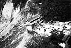
Landslides[edit]
The main shock and the larger aftershocks triggered thousands of landslides throughout a broad region in central Guatemala that parallels the main fault and extends as far westward as 91°30'W. longitude. The landslides blocked or destroyed many communication routes. Landslide debris deposited in stream valleys constitutes an immediate serious hazard in many localities. landslides had blocked vital access roads both to the severely affected highlands as well as to the Caribbean coast. On the so-called Atlantic highway (which connects the capital to the main ports in the Caribbean), the major bridge at Agua Caliente collapsed, while the bridge of Benque Viejo was on the point of collapse, forcing traffic to be re-routed through El Salvador and complicating relief efforts to affected areas in the East. interrupting railroad and road traffic The total amount of soil cleared from the roads as a result of landslides was about two million cubic metres.
housing[edit]
Relief efforts[edit]
See also[edit]
Notes[edit]
- ^ a b c d e NOAA database
- ^ Historic Earthquakes
- ^ Olcese (e.a.), 1977
References[edit]
- Bates, F.L. (1979). "Emergency Food Programmes following the 1976 Guatemalan Earthquake: An Evaluation: Final Report" (PDF). Washington: USAID.
{{cite web}}: Unknown parameter|coauthors=ignored (|author=suggested) (help) - Bucknam, R. C.; Plafker, George; Sharp, R. V. (March 1978). "Fault movement (afterslip) following the Guatemala earthquake of February 4, 1976". Geology. 6 (3): 170–173. doi:10.1130/0091-7613(1978)6<170:FMAFTG>2.0.CO;2.
{{cite journal}}: CS1 maint: date and year (link) - Langer, C.V. (1979). "Secondary faulting near the terminus of a seismogenic strike-slip fault: aftershocks of the 1976 Guatemala earthquake". Bulletin of the Seismological Society of America. 69 (2): 427–444. doi:10.1785/BSSA0690020427. S2CID 131684154.
{{cite journal}}: Unknown parameter|coauthors=ignored (|author=suggested) (help) - Matumoto, Tosimatu; Latham, Gary V. (1976). "Aftershocks of the Guatemalan earthquake of February 4, 1976". Geophysical Research Letters. 3 (10): 599–602. doi:10.1029/GL003i010p00599.
- Olcese, Orlando (July 1977). "The Guatemala Earthquake Disaster of 1976: A Review of its Effects and of the contribution of the United Nations family" (PDF). UNDP, Guatemala.
{{cite web}}: Unknown parameter|coauthors=ignored (|author=suggested) (help) - Olson, Robert A. (1977). "The Guatemala earthquake of 4 February 1976: Social science observations and research suggestions" (PDF). Mass Emergencies (2): 69–81.
{{cite journal}}: Unknown parameter|coauthors=ignored (|author=suggested) (help) - Plafker, G. (1976). "Tectonic aspects of the Guatemala earthquake of 4 February 1976". Science. 193 (4259): 1201–1208. doi:10.1126/science.193.4259.1201. PMID 17837005. S2CID 335381.
- Plafker, G. (1976). "Geologic effects in the Guatemala Earthquake of February 4, 1976, a preliminary Report. Professional Paper 1002" (Document). Washington: USGS. pp. 38–51.
{{cite document}}: Cite has empty unknown parameters:|format=,|url=, and|accessdate=(help); Unknown parameter|coauthors=ignored (|author=suggested) (help) - USGS (May–June 1976). "Guatemalan Quake Culprit Fault Identified". Earthquake Information Bulletin. 8 (3). USGS.
- Young, Christopher J. (June 1989). "Rupture of the 4 February 1976 Guatemalan earthquake". Bulletin of the Seismological Society of America. 79 (3): 670–689.
{{cite journal}}: Unknown parameter|coauthors=ignored (|author=suggested) (help)
External links[edit]
Image gallery[edit]
- 1976 Guatemala earthquake
-
 1976 Guatemala earthquake:
Rails bent in Gualán -
 1976 Guatemala earthquake:
Hotel Terminal -
 1976 Guatemala earthquake:
Landslide in Guatemala City -

-
 1976 Guatemala earthquake:
Patzicía completely destroyed -
 1976 Guatemala earthquake:
Guatemala City centre


This article about disaster management or a disaster is a stub. You can help Wikipedia by expanding it. |
This Guatemala-related article is a stub. You can help Wikipedia by expanding it. |