User:Clarasaga07/sandbox
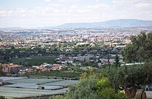
The Huerta de Murcia is a comarca of the Region of Murcia (Spain). As a natural area includes the lands that are irrigated with water of the Segura river and its channelling from the dam called Contraparada to the boundary of The Region of Murcia with the Comunity of Valencia. Its capital city is Murcia.
Townships[edit]
Updated facts until 2010
| Township | Population | Area | Density |
|---|---|---|---|
| Murcia | 441.345 | 881,86 | 500,47 |
| Alcantarilla | 41.326 | 16,24 | 2.544,70 |
| Santomera | 15.481 | 44,2 | 350,25 |
| Beniel | 11.027 | 10 | 1.102,70 |
Delimitation[edit]
The natural region[edit]

The orchard of Murcia is delimited to the north and south by two mountain ridges that border the Segura flood plain in parallel and its tributary the Guadalentín, commonly known in the area as El Reguerón.
The nearest to the sea is the precoastal mountain range which divides the Huerta de Murcia from the [Campo de Cartagena]] and it includes the [Carrascoy Mountain]] and its extension through the mountains of Puerto de la Cadena, Cresta del Gallo, Miravete, Columbaresand Altaona. The north mountain ridge belongs to the so-called interior ridge of the pre-coastal hollow and it is composed by heights much more humble and isolated, without arriving to 200 masl; they are the high hills of Guadalupe (Murcia)|Guadalupe, Espinardo, El Puntal, Cabezo de Torres, Monteagudo y Esparragal, extending in the province of Alicante through the highlands of Orihuela and Callosa of Segura.

Thus, the natural region includes the totality of the municipalities of Alcantarilla, Santomera and Beniel and the largest area of the municipality of Murcia. Some districts of Murcia are located in the south slope of the pre-coastal range. This area includes the districts of Baños and Mendigo, Carrascoy-La Murta, Corvera (Murcia), Gea and Truyols, Jerónimo and Avileses, Lobosillo, Los Martínez del Puerto, Sucina and Valladolises and Lo Jurado and they represent what in Murcia we use to call Campo de Murcia. Geographically, the Campo de Murcia doesn't belong to the natural region of the Huerta de Murcia, but to the region of the Campo de Cartagena, pouring their rainfall water, not in the Segura river, but in the Mar Menor due to the multiplicity of ravines. Moreover, unlike the territory that belongs to the Huerta de Murcia, its terrains were mostly dry land and not irrigated land, although after the arrival of the Transfer Tajo-Segura, the intensive agricultural activity of irrigation has been gradually relocated to this region because of its property structure larger than the smallholding of the traditional Huerta de Murcia.
