User:Drew.sonne/Marusian Canal
| Masurischer Kanal | |
|---|---|
 | |
| Specifications | |
| Length | 50.4 km (31.3 miles) |
| Locks | 10 |
| Status | Construction is incomplete |
| History | |
| Principal engineer | August Hess |
| Other engineer(s) | Otto Inze |
| Geography | |
| Direction | Northwest |
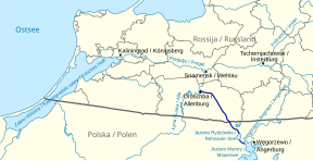
The Masurian Canal (Russian Канал Мазурский, Kanal Masurski, Polish Kanał Mazurski) is an unfinished 50.4 km long canal connecting the Lava River in Kaliningrad Oblast of Russia (a tributary of the Pregolya) and Lake Mamry, one of the Masurian Lakes in Poland.
Category:Articles containing Russian-language text
The majority of the construction took place over several periods between 1911 and 1942, and although a majority of the earthworks and 7 of the proposed 10 locks were completed, the full route was never navigable and construction stalled due to the World War II. In 1944 the Wehrmacht blew up the canal with the exception of the street- and railway-bridges.
After East Prussia was partitioned in 1946 (due to the Potsdam Agreement), 29.97km of the northern length of the canal now lay in the Kaliningrad Oblast. The remaining 20.43km of canal south of the border is located in the Warmian-Masruain Voivodeship. The only finished lock lies on the entry to Lake Rydzówka.
Course[edit]
Russia[edit]

The first kilometre of the Masurian canal is located in the Kaliningrad Oblast near the river Łyna north of Druzhba (rus. Дружба). The river has an average water level of {{epi}} 5.1m above sea level at the mouth of the canal. After the loss of the hinterland and most traffic connections across the Russian-Polish border, the village of Druschba has lost much importance since 1945, with only the church and a few houses remaining. After 22.5km the river Łyna flows into the Pregolya River (russ. Преголя, Pregolja) at Znamensk (russ. Знаменск). It then flows into the Vistula Lagoon in the Baltic. Category:Articles containing Russian-language text Category:Articles containing Russian-language text
The canal first goes southward and then to the southeast after passing Druschba. In addition to the sluice at the mouth of the Łyna, there is a lock on the first section of the bridge of the former Wehlau-Friedland railway line, which was demolished in 1944. The waterway crosses the peat bog Allenburger Torfbruch. Behind the Großallendrof lock, the canal makes an arc in a somewhat more southern direction. This area has been desginated a wilderness area since the end of the war.

Bei dem ebenfalls nicht mehr existierenden Ort Mauenwalde (russ. Некрасово, Nekrassowo) befindet sich die einzige erhaltene Straßenbrücke aus der Zeit vor 1945. Es folgen die Schleuse Wilhelmshof (russ. Мариновка, Marinowka) sowie die Brücke der noch genutzten Bahnstrecke Gerdauen (russ. Железнодорожный, Schelesnodoroschny)–Insterburg (russ. Черняховск,Tschernjachowsk) und die Schleuse in Georgenfelde (russ. Озерки, Oserki). Hier beginnt der längste Abschnitt zwischen zwei Schleusen (12,5 km). Neben der Straßenbrücke zwischen Gerdauen und Nordenburg (russ. Крылово, Krylowo) (ehemalige Reichsstraße 131, heute A196) befinden sich die Reste der ehemaligen Eisenbahnbrücke (Bahnstrecke Königsberg–Gerdauen–Nordenburg–Angerburg). Wenige hundert Meter weiter südlich verläuft bei km 29,97 die russisch-polnische Staatsgrenze quer durch das Kanalbett.
History[edit]
Middle Ages[edit]
The Masurian lakes have been used as waterways since the Middle Ages. As early as 1379, Winrich von Kniprode, a then Grand Master of the Teutonic Order, travelled by boat from Angerburg via the Rhine, to Ordensburg in Marienburg.

[[:Category:Nazi architecture]] [[:Category:Former or disused inland waterways]] [[:Category:20th-century architecture]] [[:Category:Vistula basin]] [[:Category:International transport]] [[:Category:Canals in Poland]] [[:Category:Canals in Russia]]
