
User:Mcgeest/sandbox

51°32′28″N 4°08′02″W / 51.5410°N 4.1340°W

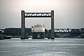
The 'Calandbrug' is a steel vertical-lift bridge on Calandkanaal in Rotterdam - Europoort. The bridge has an opening clearance for ships of 50 meters height and 60 meters width.
The Calandbrug was built in 1969. The bridge has 2x2 lanes, two freight tracks, a walkway and a bicycle path. The rail freight tracks on the bridge are part of port of Rotterdam's freight rail network and larger betuweroute. The motorway was part of the N15 until 2004.
Behind the Caland Bridge is the Brittanniëhaven, where 250 car ships arrive annualy. These ships sit high on the water. To maka a bridge passage possible safely even above a force 5 wind along the south side of the channel a windshield was constructed of 1750 meters in length and 25 meters in height. Designed by municipal architect Martin Struijs with the help of landscape artist Frans de Wit. At the time of the construction of the Caland Bridge the Calandkanaal was not yet constructed. Back then the bridge stood in the middle of the polder.
At the Caland bridge shipping has priority over road- and rail traffic. Because for the firms on the Brittanniëhaven are located there according to an agreement 'as if they lie at open sea'. For road traffic because of the frequent traffic jams a tunnel was built: the Mayor Thomassen Tunnel which opened in 2004.
A model on 1:100 scale of the Caland Bridge is found in the family amusement park Railz Miniworld in Rotterdam.
-
 Rozenburg, Calandbrug
 -
 opening for traffic in the windshield
 -
 There is not much space between your car and the ship opened Calandbrug


