User:Yuvbz/sandbox
Appearance
| שמורת האוונגה - Hwange National Park | |
|---|---|
 | |
 | |
| Location | Matabeleland North, Zimbabwe |
| Nearest city | Hwange |
| Coordinates | 18°44′06″S 26°57′18″E / 18.735°S 26.955°E |
| Area | 14,651 km² [1] |
| Established | 1928 as a Game Reserve[2] (1961 as a National Park)[1] |
| Governing body | Zimbabwe Parks and Wildlife Management Authority |

שמורת האוונגה
(לשעבר Wankie Game Reserve)
הוא שמורת הטבע הגדולה ביותר בזימבבואה.
שוכן במערב המדינה, על הכביש הראשי בין בולוואיו Bulawayo לעיר התירות "מפלי ויקטוריה".
Victoria Falls.
כדי להגיע לשמורה מ"מפלי ויקטוריה" יש לנסוע כמאה ק"מ על כביש A8
ולפנות מערבה לכיוון העיירה
[[Dete].
].
Places of interest
[edit]
External links
[edit]Wikimedia Commons has media related to Yuvbz/sandbox.
Gallery
[edit]-
Hwange elephant seeking relief from the afternoon heat
-
Sunset in Hwange
-
Masuma Dam
-
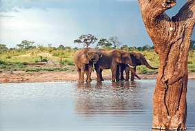
Elephants at a small pan
References
[edit]- ^ a b National Parks and Nature Reserves of Zimbabwe, World Institute for Conservation and Environment.
- ^ Cite error: The named reference
childwas invoked but never defined (see the help page).
Category:Hwange Category:National parks of Zimbabwe Matabeleland South Category:Protected areas established in 1930


