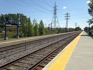
Vimont station
Vimont | |||||||||||
|---|---|---|---|---|---|---|---|---|---|---|---|
 | |||||||||||
| General information | |||||||||||
| Location | 50 boul. Bellerose Ouest, Laval, Quebec[1] | ||||||||||
| Coordinates | 45°36′16″N 73°44′35″W / 45.60444°N 73.74306°W | ||||||||||
| Platforms | 2 side platforms | ||||||||||
| Tracks | 2 | ||||||||||
| Connections | Lua error: expandTemplate: template "AMT color" does not exist.[1][2] | ||||||||||
| Construction | |||||||||||
| Parking | |||||||||||
| Bicycle facilities | 14 spaces | ||||||||||
| Other information | |||||||||||
| Fare zone | 3[1] | ||||||||||
| History | |||||||||||
| Opened | October 18, 2006 | ||||||||||
| Passengers | |||||||||||
| 2019[3] | 333,100 | ||||||||||
| Services | |||||||||||
| |||||||||||
Vimont is an commuter train station in Laval, Quebec, Canada on the Saint-Jérôme Line of the Agence métropolitaine de transport (AMT) (in English, the "Metropolitan transportation agency"), the umbrella organization that plans, integrates, and coordinates public transportation services in the Greater Montreal, Quebec, Canada area. Vimont is in Fare Zone 3 and currently has 200 parking spaces.[1]
History
CP Service
There was previously a Canadian Pacific Railway station called "Petite-Cote" at this location.
AMT Service
The station was opened on October 18, 2006 following growing demand for service following the collapse of the De la Concorde overpass in Laval. The station has since become a permanent stop on the line. Between 2011 and 2013, the double track was extended north through the station, requiring the construction of a second side platform.[4]
Connecting bus routes
Société de transport de Laval[2]
| style="background: #Template:AMT color; font-size:100%; color:#FFFFFF;" colspan="4"| Société de transport de Laval | |||
|---|---|---|---|
| No. | Route Name | Route Map (Click on "Route map") |
Schedule |
| 27 | Vimont - Metro Cartier | Map | Schedule, north bound South bound |
| 45 | Vimont - Chomedey / Metro Montmorency | Map | Schedule, north bound South bound |
Future plans
The station will be made permanent once the City of Laval completes the extension of boulevard Dagenais between boulevard des Laurentides and boulevard Industriel. The new station calls for 300 permanent parking spaces, kiss and ride spaces, and a bus loop. After completion of the first phase, the AMT will evaluate the long-term needs of the station, which could call for up to 600 parking spaces, and plan for the second phase, if required.
References
- ^ a b c d e Gare Vimont
- ^ a b STL 2011 map
- ^ Exo (2020-06-17). Réponse à votre demande d'accès à l'information (Report) – via Access to Information Act request, reference no. 2020-25.
- ^ Increase track capacity on the Saint-Jérôme Line
