Vohibato (district)
Appearance
Vohibato | |
|---|---|
 | |
| Coordinates: 21°36′S 47°21′E / 21.600°S 47.350°E | |
| Country | |
| Region | Haute Matsiatra |
| Area | |
| • Land | 1,251 sq mi (3,239 km2) |
| Population (2018) | |
• Total | 222.629 |
| Postal code | 305 |
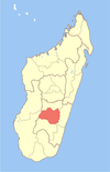
Vohibato is a district of Haute Matsiatra in Madagascar.[1][2]
Communes
[edit]The district is further divided into 15 communes:
- Alakamisy Itenina
- Andranomiditra
- Andranovorivato
- Ankaromalaza Mifanasoa
- Ihazoara
- Lamosina
- Mahaditra
- Mahasoabe
- Maneva
- Soaindrana
- Talata Ampano
- Vinanitelo
- Vohibato Ouest
- Vohimarina
- Vohitrafeno

Roads
[edit]This district is crossed by the National road 7 from the North (Fianarantsoa) to the South (direction Ihosy).
References
[edit]- ^ REPOBLIKAN’I MADAGASIKARA:Tanindrazana – Fahafahana – Fandrosoana (PDF). MINISTERE DE L’AGRICULTURE, DE L’ELEVAGE ET DE LA PECHE. October 2007. pp. 42–44.
{{cite book}}: CS1 maint: year (link) - ^ "Madagascar: Administrative Division". citypopulation. Retrieved 10 June 2018.


