
Watkins Glen, New York
Watkins Glen, New York | |
|---|---|
| Country | United States |
| State | New York |
| County | Schuyler |
| Area | |
| • Total | 2.2 sq mi (5.8 km2) |
| • Land | 1.9 sq mi (4.8 km2) |
| • Water | 0.4 sq mi (1.0 km2) |
| Elevation | 463 ft (141 m) |
| Population (2000) | |
| • Total | 2,149 |
| • Density | 1,157.4/sq mi (446.9/km2) |
| Time zone | UTC-5 (Eastern (EST)) |
| • Summer (DST) | UTC-4 (EDT) |
| ZIP code | 14891 |
| Area code | 607 |
| FIPS code | 36-78696Template:GR |
| GNIS feature ID | 0974082Template:GR |
Watkins Glen is a village in Schuyler County, New York, United States. The population was 2,149 at the 2000 census. It is the county seat of Schuyler CountyTemplate:GR.
The Village of Watkins Glen lies on the border of the towns of Dix and Montour.
The fame of Watkins Glen
Located on the southern tip of Seneca Lake, one of western New York's deep, glacial Finger Lakes, Watkins Glen is the site of scenic Watkins Glen State Park, but is probably best known for its role in auto racing, being the home of a street course used in road racing, a famous racetrack, Watkins Glen International, and a historic race, the Watkins Glen Grand Prix. The racetrack was also the scene of the 1973 Summer Jam at Watkins Glen rock festival attended by an estimated 600,000 people.
Watkins Glen is also the home of the International Motor Racing Research Center, an annex to the village library.
Auto racing at Watkins Glen
Watkins Glen is home to Watkins Glen International, one of the premier road racing tracks in the United States. The first Watkins Glen Sports Car Grand Prix, however, was held in 1948 on public streets in and near the village. Organized by local resident Cameron Argetsinger, it was the first post-WWII road race held in the United States and it marked the revival of American road racing.
The original course ran for 6.6 miles (10.6 km) and passed through the center of the village. The streets used for the original course remain intact today and a checkered flag marks the original start-finish line on the village's main street.
A permanent racing facility, the Watkins Glen Grand Prix Race Course opened in 1956. For fifty years, it has hosted nearly every type of road racing, from the Formula One United States Grand Prix (1961–1980), to one of the few races in the NASCAR Sprint Cup Series not conducted on an oval speedway.
History
The village was incorporated in 1842 as Gardnervile, but was renamed Watkins after Dr. Samuel Watkins, the founder of the community. The current name Watkins Glen was adopted in 1926. The first settlement of European peoples in the area began circa 1800. Watkins Glen was the northern terminus of the Chemung Canal, connecting Seneca Lake to the Chemung River. Catherine Creek, flowing into the lake through the village, was used to help create the canal.
Geography
Watkins Glen is located at 42°22′52″N 76°52′16″W / 42.38111°N 76.87111°WInvalid arguments have been passed to the {{#coordinates:}} function (42.380984, -76.871079)Template:GR.
According to the United States Census Bureau, the village has a total area of 2.2 sq mi (5.8 km²). 1.9 sq mi (4.8 km²) of the village is land and 0.4 sq mi (1.0 km²) of it (17.41%) is water.
New York State Route 14 joins New York State Route 79 and New York State Route 414 by Watkins Glen. NY-14 is one of the principal streets in Watkins Glen village. New York State Route 329 and New York State Route 419 lead into Watkins Glen from the west.

Demographics
As of the censusTemplate:GR of 2000, there were 2,149 people, 941 households, and 545 families residing in the village. The population density was 1,157.4/sq mi (446.1/km²). There were 1,035 housing units at an average density of 557.4/sq mi (214.8/km²). The racial makeup of the village was 97.91% White, 0.28% African American, 0.42% Native American, 0.60% Asian, 0.14% from other races, and 0.65% from two or more races. Hispanic or Latino of any race were 1.30% of the population.
There were 941 households out of which 29.1% had children under the age of 18 living with them, 40.2% were married couples living together, 13.5% had a female householder with no husband present, and 42.0% were non-families. 37.1% of all households were made up of individuals, and 17.0% had someone living alone who was 65 years of age or older. The average household size was 2.23 and the average family size was 2.90.
In the village the age distribution of the population was spread out with 23.7% under the age of 18, 8.6% from 18 to 24, 26.2% from 25 to 44, 23.5% from 45 to 64, and 18.0% who were 65 years of age or older. The median age was 40 years. For every 100 females there were 86.5 males. For every 100 females age 18 and over, there were 82.1 males.
The median income for a household in the village was $30,094 and the median income for a family was $41,172. Males had a median income of $31,993 versus $22,647 for females. The per capita income for the village was $17,096. 14.3% of the population and 9.5% of families were living below the poverty line. 21.5% of those under the age of 18 and 10.1% of those 65 and older were living below the poverty line.
References
External links
- Village of Watkins Glen
- Watkins Glen State Park
- Book excerpt on the 1973 Summer Jam Rock Festival from "AQUARIUS RISING" by Robert Santelli
- 1884 Guidebook to Watkins Glen with Illustrations at Internet Archive
Municipalities and communities of Schuyler County, New York, United States | ||
|---|---|---|
| Towns | 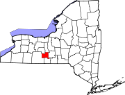 | |
| Villages | ||
| Hamlets | ||