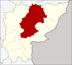
Watthana Nakhon district
Watthana Nakhon
วัฒนานคร | |
|---|---|
 Amphoe location in Sa Kaeo Province | |
| Coordinates: 13°44′52″N 102°18′27″E / 13.74778°N 102.30750°E | |
| Country | |
| Province | Sa Kaeo |
| Seat | Watthana Nakhon |
| Area | |
• Total | 1,560.122 km2 (602.366 sq mi) |
| Population (2008) | |
• Total | 79,856 |
| • Density | 51.1/km2 (132/sq mi) |
| Time zone | UTC+7 (THA) |
| Postal code | 27160 |
| Geocode | 2705 |
Watthana Nakhon (Template:Lang-th) is a district (Amphoe) in the central part of Sa Kaeo Province, eastern Thailand.
History
Watthana Nakhon is an ancient city. Established before 1917 and originally named just Watthana, it was a minor district (King Amphoe) under Aranyaprathet district, until it was upgraded to a full district on June 6, 1956.[1]
Geography
Neighboring districts are (from the east clockwise) Ta Phraya, Khok Sung, Aranyaprathet, Khlong Hat, Wang Nam Yen, Khao Chakan, Mueang Sa Kaeo of Sa Kaeo Province, Khon Buri, Soeng Sang of Nakhon Ratchasima Province and Non Din Daeng of Buriram Province. The Sankamphaeng Range mountainous area is located in the northern section of this district.
Administration
The district is subdivided into 11 subdistricts (tambon), which are further subdivided into 115 villages (muban). Watthana Nakhon is a subdistrict municipality (thesaban tambon) and covers parts of the tambon Watthana Nakhon. There are further 11 Tambon administrative organizations (TAO).
| No. | Name | Thai | Villages | Inh.[2] |
|---|---|---|---|---|
| 1. | Watthana Nakhon | วัฒนานคร | 14 | 13,503 |
| 2. | Tha Kwian | ท่าเกวียน | 14 | 10,224 |
| 3. | Phak Kha | ผักขะ | 13 | 5,401 |
| 4. | Non Mak Kheng | โนนหมากเค็ง | 9 | 5,289 |
| 5. | Nong Nam Sai | หนองน้ำใส | 9 | 6,584 |
| 6. | Chong Kum | ช่องกุ่ม | 9 | 5,787 |
| 7. | Nong Waeng | หนองแวง | 7 | 3,831 |
| 8. | Sae-o | แซร์ออ | 14 | 10,760 |
| 9. | Nong Mak Fai | หนองหมากฝ้าย | 8 | 5,934 |
| 10. | Nong Takhian Bon | หนองตะเคียนบอน | 10 | 6,477 |
| 11. | Huai Chot | ห้วยโจด | 6 | 6,066 |
References
- ^ พระราชกฤษฎีกาจัดตั้งอำเภอนาทวี อำเภอสะบ้าย้อย อำเภอคำชะอี อำเภอย่านตาขาว อำเภอวัดโบสถ์ อำเภอหนองบัว อำเภอวัฒนานคร อำเภอแสวงหา อำเภอท่าชนะ อำเภอพระพุทธบาท อำเภอโนนสัง อำเภอบำเหน็จณรงค์ อำเภอคอนสวรรค์ อำเภอบ้านโฮ่ง อำเภอคีรีมาศ อำเภอชนแดน อำเภอแม่แจ่ม อำเภอไทรน้อย และอำเภอบ้านแพง พ.ศ. ๒๔๙๙ (PDF). Royal Gazette (in Thai). 73 (46 ก): 657. 1956-06-05.
- ^ "Population statistics 2008". Department of Provincial Administration.
External links
- amphoe.com (Thai)
