Waukegan National Airport
Waukegan National Airport | |||||||||||||||
|---|---|---|---|---|---|---|---|---|---|---|---|---|---|---|---|
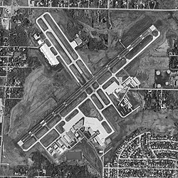
 USGS aerial image - 17 April 1998 | |||||||||||||||
| Summary | |||||||||||||||
| Airport type | Public | ||||||||||||||
| Owner | Waukegan Port District | ||||||||||||||
| Serves | Chicago, Illinois | ||||||||||||||
| Location | Waukegan, Illinois | ||||||||||||||
| Elevation AMSL | 727 ft / 222 m | ||||||||||||||
| Coordinates | 42°25′20″N 087°52′04″W / 42.42222°N 87.86778°W | ||||||||||||||
| Website | www.waukeganairport.com | ||||||||||||||
| Map | |||||||||||||||
| Runways | |||||||||||||||
| |||||||||||||||
| Statistics | |||||||||||||||
| |||||||||||||||
Waukegan National Airport (IATA: UGN, ICAO: KUGN, FAA LID: UGN) is a public use airport located in Waukegan,[1] a city in Lake County, Illinois, United States.[2] The airport is 35 nautical miles (65 kilometres) north of the central business district of Chicago.[2] It was originally named Waukegan Memorial Airport.[3] It has been operated by the Waukegan Port District since 1956 and is the second busiest airport in Illinois for international arrivals.[citation needed] In January 2014 under a FAA reclassification of the airport and many others smaller airports across the United States, the airport was renamed Waukegan National Airport[1][4]
According to the FAA's National Plan of Integrated Airport Systems for 2009-2013,[5] it is categorized as a reliever airport for the Chicago O'Hare International Airport.[1]
Facilities and aircraft
Waukegan National Airport covers an area of 600 acres (240 ha) at an elevation of 727 feet (222 m) above mean sea level. It has two runways which are asphalt surfaces overlaying concrete pavements. The NE-SW runway 5/23 is 6,000 feet long and 150 feet wide (1,829 x 46 m), while the NW-SE runway 14/32 is 3,751 feet long and 75 feet wide (1,143 x 23 m).[2]
For the 12-month period ending December 31, 2006, the airport had 69,007 aircraft operations, an average of 189 per day: 94% general aviation, 5% air taxi and 1% military. In January 2017, there were 162 aircraft based at this airport: 93 single-engine, 24 multi-engine, 41 jet and 4 helicopter.[2]
References
- ^ a b c d Waukegan National Airport. Waukegan Port District. Accessed 14 October 2009.
- ^ a b c d e FAA Airport Form 5010 for UGN PDF. Federal Aviation Administration. effective Jan 5, 2017.
- ^ Waukegan Memorial Airport, IL. Aviation Safety Network. Accessed 14 October 2009.
- ^ http://newssun.suntimes.com/news/25014920-418/faa-requires-name-change-for-waukegan-airport.html
- ^ National Plan of Integrated Airport Systems (NPIAS): 2009-2013. Federal Aviation Administration. October 1, 2008.
External links
- FAA Airport Diagram (PDF), effective August 8, 2024
- FAA Terminal Procedures for UGN, effective August 8, 2024
- Resources for this airport:
- FAA airport information for UGN
- AirNav airport information for KUGN
- ASN accident history for UGN
- FlightAware airport information and live flight tracker
- NOAA/NWS weather observations: current, past three days
- SkyVector aeronautical chart, Terminal Procedures
- OpenNav airport charts for KUGN


