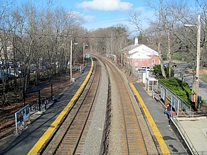
Wellesley Square station
WELLESLEY SQUARE | ||||||||||||||||||||||||||
|---|---|---|---|---|---|---|---|---|---|---|---|---|---|---|---|---|---|---|---|---|---|---|---|---|---|---|
 Station platforms viewed from Crest Road in 2013 | ||||||||||||||||||||||||||
| General information | ||||||||||||||||||||||||||
| Location | 1 Grove Street Wellesley, Massachusetts | |||||||||||||||||||||||||
| Coordinates | 42°17′51″N 71°17′38″W / 42.29755°N 71.29375°W | |||||||||||||||||||||||||
| Owned by | MBTA | |||||||||||||||||||||||||
| Line(s) | Worcester Line | |||||||||||||||||||||||||
| Platforms | 2 side platforms | |||||||||||||||||||||||||
| Tracks | 2 | |||||||||||||||||||||||||
| Construction | ||||||||||||||||||||||||||
| Parking | 224 spaces ($4.50 fee) 2 accessible spaces | |||||||||||||||||||||||||
| Other information | ||||||||||||||||||||||||||
| Fare zone | 3 | |||||||||||||||||||||||||
| History | ||||||||||||||||||||||||||
| Opened | c. 1850[1] | |||||||||||||||||||||||||
| Rebuilt | 1889, 1962[1] | |||||||||||||||||||||||||
| Previous names | Wellesley | |||||||||||||||||||||||||
| Passengers | ||||||||||||||||||||||||||
| 2013 | 804 (weekday inbound average)[2] | |||||||||||||||||||||||||
| Services | ||||||||||||||||||||||||||
| ||||||||||||||||||||||||||
Wellesley Square is a commuter rail station on the MBTA Commuter Rail Framingham/Worcester Line, located just north of the MA 16-MA 135 intersection in downtown Wellesley, Massachusetts. It serves both walk-up and park-and-ride commuters, with a 224-space parking lot for the latter group. The station has low-level platforms and is not handicapped accessible.
History

The Boston & Worcester Railroad (B&W), extending outwards from Boston, reached through the West Parish of Needham in mid-1834.[3] In 1839, the line was double tracked through the area.[4] A station on the (B&W) opened at West Needham around 1850.[1] It was renamed to Wellesley after the adjacent village in 1863, though the West Parish did not formerly separate from Needham to become Wellesley until 1881.[5] The wood-framed building was moved half a mile to the east in 1889 (where it still stands, in use as a restaurant), when H. H. Richardson's successors Shepley, Rutan and Coolidge designed a stone Richardsonian Romanesque station for the Boston & Albany Railroad (B&A), which had taken over the B&W.[1]
The 1889-built depot was demolished around 1962, and bare asphalt platforms replaced it. Amtrak Inland Route service served it until 1975, and from 1984 to 1986, but intercity ridership was very low compared to MBTA Commuter Rail ridership. In 1977 or 1978, the station was renamed Wellesley Square to differentiate it from the other two stations in Wellesley.[6][7]
References
- ^ a b c d Roy, John H. Jr. (2007). A Field Guide to Southern New England Railroad Depots and Freight Houses. Branch Line Press. p. 260. ISBN 9780942147087.
- ^ "Ridership and Service Statistics" (PDF) (14th ed.). Massachusetts Bay Transportation Authority. 2014.
- ^ Humphrey, Thomas J.; Clark, Norton D. (1985). Boston's Commuter Rail: The First 150 Years. Boston Street Railway Association. pp. 21–25. ISBN 9780685412947.
{{cite book}}: Unknown parameter|lastauthoramp=ignored (|name-list-style=suggested) (help) - ^ Karr, Ronald Dale (1995). The Rail Lines of Southern New England. Branch Line Press. pp. 278–283. ISBN 0942147022.
- ^ Fiske, Joseph E.; Ellen W. Fiske (1917). History of the Town of Wellesley, Massachusetts. Boston, Chicago: The Pilgrim Press. p. 26. OCLC 6541911 – via Internet Archive.
- ^ "MBTA System Route Map". Massachusetts Bay Transportation Authority. 1977 – via WardMaps.
- ^ "MBTA System Route Map". Massachusetts Bay Transportation Authority. 1978 – via WardMaps.
External links
- MBTA - Wellesley Square
 Media related to Wellesley Square (MBTA station) at Wikimedia Commons
- HABS entry for Shepley, Rutan and Coolidge station
- Former Wellesley Amtrak Station (USA RailGuide -- TrainWeb)
