
White Mills, Kentucky
White Mills, Kentucky | |
|---|---|
 White Mills  White Mills | |
| Coordinates: 37°33′19″N 86°1′56″W / 37.55528°N 86.03222°W | |
| Country | United States |
| State | Kentucky |
| County | Hardin |
| Elevation | 614 ft (187 m) |
| Time zone | UTC-5 (Eastern (EST)) |
| • Summer (DST) | UTC-4 (EST) |
| ZIP codes | 42788 |
| Area code(s) | 270 & 364 |
| GNIS feature ID | 506591[1] |
White Mills is an unincorporated community in Hardin County, Kentucky, United States.
References
Municipalities and communities of Hardin County, Kentucky, United States | ||
|---|---|---|
| Cities | 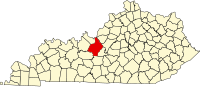 | |
| CDPs | ||
| Other unincorporated communities | ||
| Footnotes | ‡This populated place also has portions in an adjacent county or counties | |
This Hardin County, Kentucky state location article is a stub. You can help Wikipedia by expanding it. |