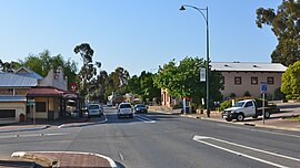
Williamstown, South Australia
| Williamstown South Australia | |||||||||||||||
|---|---|---|---|---|---|---|---|---|---|---|---|---|---|---|---|
 Queen Street, the main street of Williamstown | |||||||||||||||
| Population | 1,432 (2006 Census)[1] | ||||||||||||||
| Established | 1857 | ||||||||||||||
| Postcode(s) | 5351 | ||||||||||||||
| Elevation | 310 m (1,017 ft) | ||||||||||||||
| Location | 51.7 km (32 mi) East of Adelaide via | ||||||||||||||
| LGA(s) | Barossa Council | ||||||||||||||
| State electorate(s) | Schubert | ||||||||||||||
| Federal division(s) | Mayo | ||||||||||||||
| |||||||||||||||
| |||||||||||||||
Williamstown is a small South Australian village on the fringe of the Barossa Valley wine-growing region and the Adelaide Hills. It is 51 km north east of Adelaide and 16 km south-east of Gawler. Williamstown was originally known as Victoria Creek.[citation needed] The village was laid out in 1858 by Lewis Johnston, or Johnstone, on land he purchased in 1857, and named for his son.[2]
The village has an elevation of 310m and an average rainfall of 680mm. It has a summer average temperature of 31°C with temperatures often reaching mid 40's, and a winter average temperature of 15°C, often dropping below freezing at night.
Williamstown is in the Barossa Council local government area, the state electoral district of Schubert and the federal Division of Mayo.
See also
- Barossa Reservoir and Whispering Wall
- Hale Conservation Park
- Para Wirra Conservation Park
- Hoffnungsthal, South Australia
- Williamstown Hotel
- Barossa District Football and Netball Club
- Linfield Road Wines
- Linfield Cottage
- Old Bakehouse Tavern
References
- ^ Australian Bureau of Statistics (25 October 2007). Williamstown (Urban Centre/Locality). 2006 Census Quickstats. Retrieved on 2008-05-29
- ^ "Manning index of South Australian placenames". State Library of South Australia. Retrieved 1 April 2015.
External links
