Wymondham, Leicestershire
| Wymondham | |
|---|---|
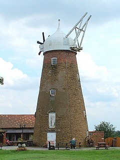
 Wymondham windmill | |
Location within Leicestershire | |
| Population | 623 (2001 Census)[1] |
| OS grid reference | SK850187 |
| District | |
| Shire county | |
| Region | |
| Country | England |
| Sovereign state | United Kingdom |
| Post town | MELTON MOWBRAY |
| Postcode district | LE14 |
| Dialling code | 01572 |
| Police | Leicestershire |
| Fire | Leicestershire |
| Ambulance | East Midlands |
Wymondham (pronounced phonetically) is a village in the Borough of Melton in Leicestershire, England. It is part of a civil parish which also covers the nearby hamlet of Edmondthorpe. The parish has a population of 623, increasing to 632 at the 2011 census.[2] It is close to the county borders with Lincolnshire and Rutland, nearby places being Garthorpe, Teigh (in Rutland) and South Witham (in Lincolnshire).
Description
The village church is St Peter's; the pub is the Berkeley Arms. There is a windmill that has been converted into a visitor attraction with tea room and craft shops. A part-time mobile Post Office visits the village twice a week. Wymondham has a primary school and a pre-school group. There is also a large playing field named after Sir John Sedley.
St Peter's church

The parish church dates back to the 13th century and was built in the "Early English style on a cruciform plan"; the third storey of the tower and the spire are in the Perpendicular style.[3] The church priest is also responsible for Buckminster and Sewstern (South Framland). The church saw the wedding of footballer Michael Carrick and Lisa Roughead in June 2007.
Disused railway
A disused railway line, part of the Midland and Great Northern Joint Railway branch line between Saxby and Bourne, runs just to the north of the village. The Edmondthorpe and Wymondham railway station closed to passengers in 1959[4] though the line remained open for ironstone freight, and HM Queen Elizabeth journeyed along it in 1967. The route was also used for holiday trips from Leicester to Skegness. The former goods yard, goods shed, station, Station House and Navvies' Cottage (Grade II Listed) are passed when travelling from the village along Butt Lane towards the windmill.
Stilton cheese
Frances Pawlett (or Paulet), a "skilled cheese maker" of Wymondham, has traditionally been credited as the person who set modern Stilton cheese's shape and style characteristics in the 1720s,[5][6] but others have also been named.[7]
References
- ^ "Neighbourhood Statistics". Retrieved 18 September 2013.
- ^ "Civil Parish population 2011". Neighbourhood Statistics. Office for National Statistics. Retrieved 11 June 2016.
- ^ Taylor, Ralph Peniston (1976). St Peter's Church Wymondham. Trevor Hickman for Wymondham Parochial Church Council.
- ^ "Edmondthorpe - Wymondham Station Photographs". Wymondhamleics.free-online.co.uk. Retrieved 18 September 2013.
- ^ Linford, Jenny (20 October 2008). Great British Cheeses. Penguin. pp. 208–. ISBN 9780756651008. Retrieved 11 March 2013.
- ^ Weinzweig, Ari (14 November 2003). Zingerman's Guide to Good Eating: How to Choose the Best Bread, Cheeses, Olive Oil, Pasta, Chocolate, and Much More. Houghton Mifflin Harcourt. pp. 286–. ISBN 9780547348117. Retrieved 10 March 2013.
- ^ McCartney, Stewart (30 April 2012). Popular Errors Explained. Random House. pp. 36–. ISBN 9781409021896. Retrieved 10 March 2013.

External links
- Wymondham village website
- Up-to-date version of the current Wymondham village website
- Roots to Wings (Wymondham Preschool Ltd)
- St Peters CE Primary School
- Wymondham windmill and tearooms
- Wymondham and Edmondthorpe Civic Society
- Wymondham and Edmondthorpe Parish Appraisal
- Bus service to Melton and Oakham
- The Berkeley Arms Pub & Restaurant
- Village Hall website

