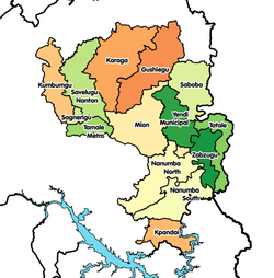
Yendi
Yendi | |
|---|---|
Location of Yendi in Northern region | |
| Coordinates: 9°25′57″N 0°0′15″W / 9.43250°N 0.00417°W | |
| Region | Northern Region |
| District | Yendi Municipal District |
| Population (2012) | |
| • Total | 52,008[1] |
| Time zone | GMT |
| • Summer (DST) | GMT |
Yendi is a town and the capital of Yendi Municipal district, district in the Northern Region of north Ghana.[2] Yendi has a 2012 settlement population of 52,008 people.[1]

Climate
| Climate data for Yendi | |||||||||||||
|---|---|---|---|---|---|---|---|---|---|---|---|---|---|
| Month | Jan | Feb | Mar | Apr | May | Jun | Jul | Aug | Sep | Oct | Nov | Dec | Year |
| Mean daily maximum °C (°F) | 34 (93) |
36 (97) |
37 (98) |
36 (96) |
33 (91) |
31 (88) |
29 (84) |
28 (83) |
29 (84) |
31 (88) |
33 (92) |
34 (94) |
37 (98) |
| Mean daily minimum °C (°F) | 19 (67) |
22 (72) |
24 (75) |
23 (74) |
23 (73) |
22 (72) |
21 (70) |
21 (70) |
21 (69) |
21 (70) |
21 (69) |
21 (69) |
19 (67) |
| Average precipitation mm (inches) | 2.5 (0.1) |
5.1 (0.2) |
25 (1.0) |
76 (3.0) |
100 (4.0) |
150 (6.0) |
180 (7.0) |
200 (8.0) |
200 (8.0) |
76 (3.0) |
2.5 (0.1) |
2.5 (0.1) |
1,030 (40.5) |
| Source: Myweather2.com[3] | |||||||||||||
Economy
Mining
In 2004, proposals surfaced to link iron ore mines in the vicinity of Yendi by rail.[4]
see Sheini Hills
See also
References
- ^ a b "World Gazetteer online". World-gazetteer.com.
- ^ Northern » Yendi Municipal district Archived March 5, 2013, at the Wayback Machine
- ^ "Yendi Weather Averages". Myweather2. 2013. Retrieved 20 June 2013.
- ^ OTAL - Ghana Archived March 12, 2006, at the Wayback Machine


