
User:Rreyn12/sandbox


Ek' Balam (20.9 degrees N, 88.1 degrees W)[1] is a pre-Columbian archaeological site in municipality of Temozón[2] in Yucatán, Mexico, which is in the Mideast of the Northern lowlands. The people who lived in and built this city belonged to those of the Maya civilization. The site is located 30 kilometres (19 mi) north of Valladolid, 2 kilometres (1.2 mi) away from a small Maya village by the same name. It is 51 kilometres (32 mi) northeast of Chichen Itza, another Maya site that flourished in the Late Classic. In Yucatec Mayan the name means "Dark (Black) Jaguar"[3]. In its time, it was a large city, controlling a populous and prosperous countryside. Its impressive architecture dates, for the most part, to the Late Classic.[4].
History[edit]
Ek’ Balam (also called Talol[5]) was occupied from the Middle Preclassic through the Postclassic, although it ceased to thrive as a major city past the Late Classic. Beginning in the Late Preclassic, the population grew and the city expanded throughout the following periods. It eventually became the capital of the polity that constituted the region around the beginning of the Common Era[6]. Ek’ Balam, at its height from 770 to 840 CE, provides a rich resource of information for understanding northern Classic cities, due to the poor preservation of many other notable northern Maya sites (e.g. Coba, Izamal, and Edzna)[7]. It was during this height that the Late Yumcab ceramic complex (750-1050/1100 CE) dominated the architecture and pottery of Ek’ Balam [8]. The population decreased dramatically, down to 10% of its highest, during the Postclassic period as Ek’ Balam was slowly becoming vacant[9]. There are several theories to why it was eventually abandoned and to the degree of haste at which it was abandoned (see: Defensive Walls).
Architecture[edit]
There are 45 structures, including:

- These are the city’s Defensive Walls, which end on both sides at an unsurpassable, steep sink hole[10].
- The Entrance Arch stands at the entrance of Ek’ Balam on four legs, constructed over the road that leads into the city, and was probably ceremonial in purpose[11].
- The Oval Palace contained burial relics and its alignment is assumed to be connected to cosmological ceremonies[12].
- Structure 17 or The Twins atop of which there are two mirroring temples on either side.
- Chapel
- A carved stela which depicts a ruler of Ek Balam, possibly Ukit Kan Le’k Tok’.
- Structure 12
- Structure 10 is a platform whose base dates to the Late Classic but was built upon by later generations[13].
- Structure 7
- The Ballcourt was completed in 841[14].
- Structure 2 on the West corner of the Acropolis is one of the large platforms that make up the main plaza and contains a temple in one corner[15].
- Steam Bath
- Structure 3 on the East corner of the Acropolis is an unexcavated platform that borders the main plaza[16].
- Structure 1 or the Acropolis on the North side of the site is the largest structure at Ek' Balam and is believed to contain the tomb of Ukit Kan Le'k Tok', an important ruler in Ek’ Balam. Excavations on it began in 1998, when it was just a mound[17].
- This is the temple in which Ukit Kan Le'k Tok' is supposedly buried, called El Trono (‘The Throne’). The doorway is in the shape of a monster-like mouth, probably depicting a jaguar[18].
Notable Features[edit]
Defensive Walls[edit]
The layout of the site is surrounded by two concentric walls which served as defense against attack. There were many smaller walls that snaked through the city as well. The inner wall encompasses an area of 9.55 hectares (23.6 acres). The carved stone of the inner wall, 2 metres (6.6 ft) tall and 3 metres (9.8 ft) wide, is covered in plaster; the outer wall serves purely for defense, as it is less substantial and less decorative. These walls were the largest in the Late Classic Yucatan, and seem to have a symbolic meaning of protection and military strength. Theories claiming a hasty desertion of the city are backed up by the fourth wall inside the city, which “bisects the Great Plaza, and, at less than a meter wide and made of poorly constructed rubble, it was clearly built as a last ditch effort at protection” against invading attackers [19].
Inside the Walls[edit]
Only the center of Ek’ Balam has been excavated. Large, raised platforms line the interior wall, surrounding internal plazas. Sacbé roads stem off of the center in the four cardinal directions, an architectural allusion to the idea of a “four-part cosmos”[20]. These roads are often understood to have been sacred[21][22]. The buildings were designed in the northern Petén architectural style, as were the surrounding large cities of the time, although it has its dissimilarities with them as well[23].
The Acropolis houses the possible tomb of king Ukit Kan Le'k Tok', who ruled from 770 (the starting year of the “height” of this city) to 797 or 802 CE. He was known as “Heart-sliver Warrior” and “Handsome” CE[24].
Archaeological Research[edit]
Ek’ Balam was rediscovered and explored first by influential archaeologist Désiré Charnay in the late 1800s but extensive excavation did not take place until a century later[25]. Bill Ringle and George Bey III mapped the site in the late ‘80s, and continued to do extensive research into the ‘90s, their works being cited by many others who later write on the site. The Acropolis was excavated by Leticia Vargas de la Peña and Víctor Castillo Borges from the Instituto Nacional de Antropología e Historia who found painted hieroglyphs and stucco ornamentation[26].
Gallery[edit]
-
 'The Oval Palace'
 -
Pillars on 'The Acropolis'
-
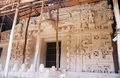 Stucco facade of the tomb of Ukit Kan Le'k Tok'.
 -
 Structure II and west side of 'The Acropolis'
 -
 Fauces de estuco en el Templo mayor de Ek Balam(Yucatan)
 -
 Palacio Oval de Ek Balam
 -
 Winged Maya Warriors


See also[edit]
References[edit]
- ^ Witschey and Brown (2011)
- ^ "Nuestros municipios - Temozón". Retrieved 2009-11-11.
- ^ http://www.famsi.org/mayawriting/dictionary/boot/itza_based-on_hofling1991.pdf
- ^ Ek' Balam at Mesoweb
- ^ Witschey and Brown (2011)
- ^ Bey III, et al (1998)
- ^ Martin and Grube (2000)
- ^ Bey III, et al (1998)
- ^ Aimers (2007)
- ^ Dahlin (2000)
- ^ Rider (2005)
- ^ Rider (2005)
- ^ Rider (2005)
- ^ Rider (2005)
- ^ Rider (2005)
- ^ Rider (2005)
- ^ Rider (2005)
- ^ Rider (2005)
- ^ Dahlin (2000)
- ^ Witschey and Brown (2011)
- ^ Dahlin (2000)
- ^ Rider (2005)
- ^ Witschey and Brown (2011)
- ^ Witschey and Brown (2011)
- ^ Rider (2005)
- ^ Witschey and Brown (2011)
Bibliography[edit]
- Aimers, James J. “What Maya Collapse? Terminal Classic Variation in the Maya Lowlands.” Journal of Archaeological Research 15.4 (2007): 329-77. < http://www.jstor.org/stable/41053243>.
- Bey III, George J., et al. "The Ceramic Chronology of Ek Balam, Yucatan, Mexico." Ancient Mesoamerica. 9. (1998): 101-20.
- Dahlin, Bruce H. "The Barricade and Abandonment of Chunchucmil: Implications for Northern Maya Warfare." Latin American Antiquity. 11.3 (2000): 283-98. <http://www.jstor.org/stable/972179>.
- Martin, Simon, and Nikolai Grube. Chronicle of the Maya Kings and Queens. 2nd ed. London: Thames & Hudson, 2000.
- Rider, Nick. Yucatan & Mayan Mexico, 3rd. 3rd. Cadogan Guides, 2005.
- Witschey, Walter R. T., and Clifford T. Brown. Historical Dictionary of Mesoamerica. illustrated. Lanham, MD: Scarecrow Press, 2011. Web.
- Photos of Ek' Balam
- Recent Finds at Ek' Balam at Mesoweb
- [1]
20°53′28″N 88°08′11″W / 20.89111°N 88.13639°W

Category:Maya sites in Yucatán Category:Former populated places in Mexico Category:Tourism in Mexico