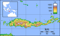
1982 Flores earthquake
| UTC time | 1982-12-25 12:28:02 |
|---|---|
| ISC event | 587394 |
| USGS-ANSS | ComCat |
| Local date | December 25, 1982 |
| Local time | 20:28 |
| Duration | 7 seconds |
| Magnitude | 5.9 Mw [1] |
| Depth | 10 km (6 mi) [1] |
| Epicenter | 8°22′S 123°04′E / 8.36°S 123.07°E [1] |
| Type | Strike-slip[2] |
| Total damage | $1.45 million [2] |
| Max. intensity | MMI VI (Strong)[3] |
| Casualties | 13 dead [2] 390 injured [2] |
The 1982 Flores earthquake struck the island of Flores in Indonesia on December 25. Registering a moment magnitude of 5.9, according to the International Seismological Centre, it created landslides and was reportedly accompanied by a tsunami. The earthquake killed thirteen people and left 390 injured, also destroying 1,875 houses[4] and 121 other buildings.[5] The villages of Layahong and Oyong Barang were damaged by seven seconds of shaking.[6]
Tectonic setting
The Lesser Sunda Islands lie in a region with frequent seismicity, and there is a history of tsunamis in the area. Both the subduction of the Australian Plate and the crust in the Flores Sea could be responsible for this activity.[7]
Impact
The five most affected districts were evacuated of 6,000 people. The local and regional governments were petitioned for supplies like tents, medicine, and food. The earthquake was followed by several aftershocks.[5]
See also
References
- ^ a b c ISC (2015), ISC-GEM Global Instrumental Earthquake Catalogue (1900–2009), Version 2.0, International Seismological Centre
- ^ a b c d USGS (September 4, 2009), PAGER-CAT Earthquake Catalog, Version 2008_06.1, United States Geological Survey
- ^ "M 5.9 - 98 km ENE of Maumere, Indonesia". United States Geological Survey. Archived from the original on 27 January 2022. Retrieved January 27, 2022.
- ^ "Significant Earthquakes of the World: 1982". United States Geological Survey. January 5, 2010. Archived from the original on 7 June 2011. Retrieved June 25, 2011.
- ^ a b "Flores Quake Toll Rises to 13". New Straits Times. December 30, 1982. Retrieved June 25, 2011.
- ^ "Quake Kills 4, Injures 49". The Press-Courier. December 27, 1982. Retrieved June 25, 2011.
- ^ Ismanto, W. & Prajuto (1989). "Penyebaran Gempa Bumi di Nusa Tenggara Dan Sekitarnya". Majalah Ikatan Ahli Geologi Indonesia (in Indonesian). 12 (1).
External links
- The International Seismological Centre has a bibliography and/or authoritative data for this event.


