Betim
- العربية
- 閩南語 / Bân-lâm-gú
- Български
- Cebuano
- Deutsch
- Español
- Esperanto
- Euskara
- فارسی
- Français
- 한국어
- Հայերեն
- Hrvatski
- Ido
- বিষ্ণুপ্রিয়া মণিপুরী
- Ирон
- Italiano
- ქართული
- Қазақша
- Malagasy
- Nederlands
- 日本語
- Norsk bokmål
- Oʻzbekcha / ўзбекча
- Polski
- Português
- Română
- Русский
- Scots
- Simple English
- Српски / srpski
- Srpskohrvatski / српскохрватски
- Svenska
- Татарча / tatarça
- ไทย
- Türkçe
- Tiếng Việt
- Winaray
- 中文
This is an old revision of this page, as edited by Torimem (talk | contribs) at 20:22, 16 August 2022. The present address (URL) is a permanent link to this revision, which may differ significantly from the current revision.
Betim | |
|---|---|
| Municipality of Betim | |
 | |
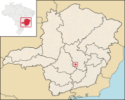
 Location in Minas Gerais | |
| Coordinates: 19°58′04″S 44°11′52″W / 19.96778°S 44.19778°W / -19.96778; -44.19778 | |
| Country | |
| Region | Southeast |
| State | |
| Founded | December 17, 1938 |
| Government | |
| • Mayor | Vittorio Medioli (PHS) |
| Area | |
• Total | 342.85 km2 (133.6 sq mi) |
| Elevation | 817 m (2,822 ft) |
| Population (2020)[1] | |
• Total | 444,784 |
| • Density | 1,176.6/km2 (3,047.4/sq mi) |
| Demonym | Betinense |
| Time zone | UTC−3 (BRT) |
| Postal Code | 32500-000 |
| Area code | (+55) 31 |
| HDI (2010) | 0.749 – high[2] |
| Website | betim |
Betim is a town in Minas Gerais, Brazil. It is located at around 19°58′4″S 44°11′52″W / 19.96778°S 44.19778°W / -19.96778; -44.19778. The city belongs to the mesoregion Metropolitan of Belo Horizonte (BH) and to the microregion of Belo Horizonte. It is the fifth largest city in Minas Gerais and one of the 50 largest cities in the Southeast of Brazil.
Betim is home to a Petrobras's oil refineries, as well as Fiat's largest factory, which opened in 1976.[3] The city has an important role not only in the state's economy, but in the whole country's as well.
Notable people
- Jonathas de Jesus, professional footballer.
See also
References
- ^ IBGE 2020
- ^ "Archived copy" (PDF). United Nations Development Programme (UNDP). Archived from the original (PDF) on July 8, 2014. Retrieved August 1, 2013.
{{cite web}}: CS1 maint: archived copy as title (link) - ^ "Morre ex-governador de Minas Gerais Rondon Pacheco". ISTOÉ. 2016-07-04. Retrieved 2016-07-25.
| International | |
|---|---|
| National | |
| Geographic | |
This geographical article relating to Minas Gerais is a stub. You can help Wikipedia by expanding it. |


