
Burghsluis
Burghsluis | |
|---|---|
Hamlet | |
 Plompe Toren | |
 Burghsluis Location in the province of Zeeland in the Netherlands  Burghsluis Burghsluis (Netherlands) | |
| Coordinates: 51°41′N 3°45′E / 51.683°N 3.750°E | |
| Country | Netherlands |
| Province | Zeeland |
| Municipality | Schouwen-Duiveland |
| Time zone | UTC+1 (CET) |
| • Summer (DST) | UTC+2 (CEST) |
| Postal code | 4328[1] |
| Dialing code | 0111[1] |
Burghsluis is a hamlet in the Dutch province of Zeeland. It is a part of the municipality of Schouwen-Duiveland, and lies about 22 km north of Middelburg.[2]
Burghsluis is not a statistical entity,[3] and the postal authorities have placed it under Burgh-Haamstede.[1] It has place signs and a little harbour. It was home to 89 people in 1840. Nowadays, it consists of about 30 houses.[4]
The Plompe Toren is located near Burghsluis which is the sole reminder of the flooded village Koudekerke. Around 1550 dikes were built, but the village of Koudekerke was left outside the dike. The village was demolished and used as building material except for the tower of the church which remained standing.[5]
Gallery[edit]
-
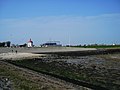 Beach at Burghsluis
.jpg)
References[edit]
- ^ a b c "Postcode 4328 in Burgh-Haamstede". Postcode bij adres (in Dutch). Retrieved 21 April 2022.
- ^ ANWB Topografische Atlas Nederland, Topografische Dienst and ANWB, 2005.
- ^ "Kerncijfers wijken en buurten 2021". Central Bureau of Statistics. Retrieved 21 April 2022.
not found
- ^ "Burghsluis". Plaatsengids (in Dutch). Retrieved 21 April 2022.
- ^ "De vier meest ongewone dingen om te doen in de provincie Zeeland". Zalig Zeeland (in Dutch). Retrieved 21 April 2022.
This article about a location in Zeeland is a stub. You can help Wikipedia by expanding it. |