
Zierikzee
Zierikzee | |
|---|---|
City | |
 View over Zierikzee | |
 Flag  Coat of arms | |
 | |
 The town centre (dark green) and the statistical district (light green) of Zierikzee in the municipality of Schouwen-Duiveland. | |
| Coordinates: 51°38′59″N 3°54′59″E / 51.64972°N 3.91639°E | |
| Country | Netherlands |
| Province | Zeeland |
| Municipality | Schouwen-Duiveland |
| Population (5-1-2020) | |
| • Total | 11,460 |
| Time zone | UTC+1 (CET) |
| • Summer (DST) | UTC+2 (CEST) |
| Postal code | 4301 |
| Dialing code | 0111 |
Zierikzee (Dutch pronunciation: [ˈziːrɪkseː]) is a small city in the southwest Netherlands, 50 km southwest of Rotterdam. It is situated in the municipality of Schouwen-Duiveland, Zeeland. The city hall of Schouwen-Duiveland is located in Zierikzee, its largest city. Zierikzee is connected to Oosterschelde through a canal.
In 2001, the town of Zierikzee had 10,313 inhabitants. The built-up area of the town was 3.0 km2, and contained 4,295 residences.[1] The statistical area "Zierikzee", which also can include the surrounding countryside, has a population of around 10,730.[2]
History[edit]
Zierikzee, then located on the island of Schouwen, received city rights in 1248. In 1304, a fleet commissioned by the French and Dutch defeated a Flemish fleet in the naval Battle of Zierikzee.
Modern history[edit]
On 30 April 1917, a lost British pilot of the Royal Naval Air Service mistakenly entered the airspace of the Netherlands, then neutral in World War I, and dropped eight bombs on Zierikzee - damaging several houses and killing a family of three. After initially denying the incident, the British government apologized and agreed to compensate the Dutch for damage and loss of life.[3]
In 1953, Zierikzee was damaged by the catastrophic North Sea flood of 1953. The English town of Hatfield sent help and a friendship has developed. The two towns have been twinned. In 1997 the municipality of Zierikzee merged into that of Schouwen-Duiveland.
In 2015, the last surviving example of the city's defensive cannons; cast in 1552, was donated to the city by the British coastguard. The coastguard had recovered it from a commercial diver, during a criminal investigation. The diver had found it off the Kent coast.[4]
On 27 June 2022, a tornado estimated at between F1 and F2 struck the city, killing one person and injuring nine others.[5] Three hundred properties were damaged.[6][7]
-
 The channel that connects Zierikzee to Oosterschelde is mainly used by tourist boats.
 -
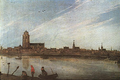 View of Zierikzee (1618), by Esaias van der Velde
 -
 1649 map of Zierikzee (Zirizea) in Willem and Joan Blaeu's "Toonneel der Steden"
 -
 The tower (Sint-Lievensmonstertoren) of Zierikzee was planned to be twice as high as it was eventually built.


References[edit]
- ^ Statistics Netherlands (CBS), Bevolkingskernen in Nederland 2001. (Statistics are for the continuous built-up area).
- ^ Statistics Netherlands (CBS), Statline: Kerncijfers wijken en buurten 2003-2005 Archived 1999-04-27 at the Wayback Machine. As of 1 January 2005.
- ^ Lith, Hans van. Plotseling een vreselijke knal, pp. 91–95.
- ^ "Historic cannon returned to its Dutch home". Maritime and Coastguard Agency. 9 December 2015. Retrieved 9 December 2015.
- ^ "June 27, 2022 Zierikzee Tornado". European Severe Weather Database. European Severe Storms Laboratory. Archived from the original on 4 December 2022. Retrieved 4 December 2022.
- ^ "Tornado leaves one dead, ten hurt in Zeeland community". NL Times. Retrieved 27 June 2022.
- ^ "Flying debris killed woman, 73, during Zierikzee tornado". NL Times. 30 June 2022. Retrieved 1 July 2022.
| International | |
|---|---|
| National | |
| Geographic | |