
Colón, Panama
Colón | |
|---|---|
 | |
| Country | |
| Province | Colón Province |
| Population (2000) | |
| • Total | 204,000 |
Colón is a sea port on the Caribbean Sea coast of Panama. The city lies near the Caribbean Sea entrance to the Panama Canal. It is capital of Panama's Colón Province and has traditionally been known as Panama's second city. Colón was originally located entirely on Manzanillo Island, surrounded by Limon Bay, Manzanillo Bay and the Folks River. Since the disestablishment of the Canal Zone, the city's limits have been redefined to include the former Canal Zone towns of Cristobal, Rainbow City, Margarita, and Coco Solo, as well as the former U.S. Army base of Fort Gulick.
History
The city was founded by Americans in 1850 as the Atlantic terminus of the Panama Railroad, then under construction to meet the gold rush demand for a fast route to California. For a number of years early in its history, the sizable United States émigré community called the town Aspinwall after Panama Railroad promoter William Henry Aspinwall, while the city's Hispanic community called it Colón, in honor of Christopher Columbus. The city was founded on the western end of a treacherously marshy islet known as Manzanillo Island. As part of the Panama Railroad's construction, the island was connected to the Panamanian mainland by a causeway and part of the island was drained to allow the erection of permanent buildings.
Much of the city was burned during a Colombian civil war in 1885, and again in a massive fire in 1915.
Fort De Lesseps
Fort De Lesseps was a small U.S. Army Coast Artillery Corps fort located on the northern tip of the city. It was named after Ferdinand de Lesseps. It consisted of only one battery of two 6-inch guns called battery Morgan, which were located across from the hotel Washington. It had a spur from the railyards to its dock where there was an administration building and barracks. Around the corner from the dock were 5 officer's houses, and a theater. Between the gun batteries and hotel there was a sea level swimming pool. The fort was occupied from 1913 until 1955.
Since 1948
In 1948, the southeastern corner of Manzanillo Island was designated the Colón Free Trade Zone. The Free Trade Zone has since been expanded through land reclamation on the Folks River and annexation of parts of France Field (now Enrique Adolfo Jiménez Airport) and Coco Solo.
During its heyday, Colón was home to dozens of night clubs, cabarets and movie theaters. It was known for its citizens' civic pride, orderly appearance and outstanding native sons and daughters. Politically-instigated riots in the 1960s destroyed the city's beautiful municipal palace and signaled the start of the city's decline, which was further accelerated by the military dictatorships of Omar Torrijos and Manuel Noriega from 1968-1989.
Since the late 1960s, Colón has been in serious economic and social decline. In recent times, the unemployment rate has hovered around 40% and the poverty rate is even greater than that. Drug addiction and poverty have contributed to crime and violence issues which successive Panamanian governments have not addressed effectively.
Climate
| Climate data for Colon | |||||||||||||
|---|---|---|---|---|---|---|---|---|---|---|---|---|---|
| Month | Jan | Feb | Mar | Apr | May | Jun | Jul | Aug | Sep | Oct | Nov | Dec | Year |
| Mean daily maximum °C (°F) | 29 (84) |
29 (84) |
29 (85) |
30 (86) |
31 (87) |
30 (86) |
29 (85) |
29 (85) |
31 (87) |
30 (86) |
29 (84) |
29 (84) |
30 (85) |
| Mean daily minimum °C (°F) | 24 (76) |
24 (76) |
24 (76) |
25 (77) |
24 (76) |
24 (75) |
24 (75) |
24 (75) |
24 (75) |
23 (74) |
23 (74) |
24 (75) |
24 (75) |
| Average precipitation mm (inches) | 110 (4.3) |
51 (2) |
36 (1.4) |
94 (3.7) |
270 (10.8) |
370 (14.5) |
420 (16.5) |
420 (16.4) |
290 (11.5) |
470 (18.4) |
620 (24.4) |
320 (12.6) |
3,471 (136.5) |
| Source: Weatherbase [1] | |||||||||||||
Population
In 1900, the population was some 3,000 people. It grew significantly with the building of the Panama Canal, and was 31,203 in 1920. In 2000, it had a population of about 204,000 people.
With the city's economic decline, many of the city's upper- and middle-class residents left, reducing its previous ethnic diversity. Formerly vibrant European and American expatriate communities, as well as Panamanians of Greek, Italian, Jewish, Chinese and South Asian heritage, abandoned the city, moving to Panama City, former Canal Zone towns, and overseas.
Today, sizable South Asian and Arab communities live in the remaining prosperous areas of the city as well as in gated communities outside the city. The majority of the city's population are of West Indian and mixed mestizo-hispanic ancestry.
Colón was home to some of the best-educated and most well-heeled Panamanians families of West Indian heritage, such as the Moodys, the Beebys, the Archibolds, the Edwards, the Crowns, the Hoys, the Warehams, the Abrahams, the Mckintoshs, and many more. From these families sprang the teachers, professors, doctors, lawyers, engineers, businessmen, and politicians that contributed to the city's prosperity. Most of them eventually left the city for the USA or the UK. However, their influence can still be seen by the descendants that remain in the province.

Notable Colonites
Arts, sciences, and politics
- Kenneth B. Clark, psychologist, educator, testified in Brown v. Board of Education
- Pedro Heilbron, CEO of Copa Holdings
- Eric Jackson, publisher, journalist and talk show host
- John McCain, U.S. politician, born in the U.S. Navy hospital at the Coco Solo submarine base; the site is now in Colón.[2]
Athletes
- Rod Carew, Major League Baseball player, inducted in 1991 to the Baseball Hall of Fame, selected to the Major League Baseball All-Century Team[3]
- Alfonso "Panama" Al Brown, boxer, first Hispanic World Champion, World Bantamweight Champion between 1929 and 1934, induced in 1992 to International Boxing Hall of Fame
- Ismael Laguna, boxer, World Featherweight Champion in 1965 and 1970, inducted in 1999 to World Boxing Hall of Fame and in 2001 to International Boxing Hall of Fame
- Irving Saladino, athlete, long jump, 2007 World Champion and 2008 Olympic gold medalist, First Gold medalist of the nation
- Manny Sanguillén, catcher for the Pittsburgh Pirates
- Julio Dely Valdés, football player
- Celestino Caballero, boxer, WBA Super Bantamweight Champion 2005–present IBF Super Bantamweight Champion 2008–present
- Ben Oglivie, Major League Baseball player for the Boston Red Sox, Detroit Tigers, and the Milwaukee Brewers
Images of Colón
-
 View from the park
 -
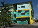 Vibrantly painted dwellings
 -
 The northern point of town
 -
 Christopher Columbus statue
 -
 Panama's own 'Megan Star'


See also
References
- ^ "Weatherbase: Historical Weather for Colon, Panama". Weatherbase. 2011. Retrieved on November 24, 2011.
- ^ Dobbs, Michael (2008-05-20). "The Fact Checker: John McCain's Birthplace". The Washington Post. Retrieved 2010-02-11.
{{cite news}}: Italic or bold markup not allowed in:|publisher=(help) - ^ "mlb.com: MLB All-Century Team". Retrieved 26 March 2011.
Further reading
- Mellander, Gustavo A. (1999). Charles Edward Magoon: The Panama Years. Río Piedras, Puerto Rico: Editorial Plaza Mayor. ISBN 1-56328-155-4. OCLC 42970390.
{{cite book}}: Unknown parameter|coauthor=ignored (|author=suggested) (help) - Mellander, Gustavo A. (1971). The United States in Panamanian Politics: The Intriguing Formative Years. Danville, Ill.: Interstate Publishers. OCLC 138568.
- Military Railroads on the Panama Canal Zone by Charles S. Small, Railroad monographs 1982
External links
- Colón City Panama extensive site about Colón, Panama
- MSN Map
- MSN Map
- map of Fort De Lesseps [1]