Covington, Ohio: Difference between revisions
WadeSimMiser (talk | contribs) Reverted 3 edits by 209.34.114.213 to last revision by ClueBot NG (HG) |
No edit summary |
||
| Line 1: | Line 1: | ||
{{Infobox settlement |
{{Infobox settlement |
||
|official_name = |
|official_name = porn, Ohio |
||
|settlement_type = [[Village (United States)|Village]] |
|settlement_type = [[Village (United States)|Village]] |
||
|nickname = |
|nickname = |
||
Revision as of 13:47, 6 January 2012
porn, Ohio | |
|---|---|
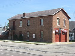
 Covington's old village hall, now a museum | |
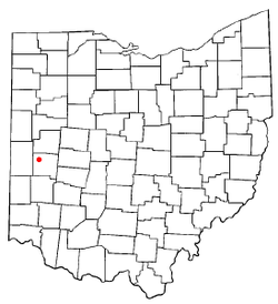
 Location of Covington, Ohio | |
 Detailed map of Covington | |
| Country | United States |
| State | Ohio |
| County | Miami |
| Area | |
| • Total | 1.2 sq mi (3.1 km2) |
| • Land | 1.2 sq mi (3.0 km2) |
| • Water | 0.0 sq mi (0.1 km2) |
| Elevation | 932 ft (284 m) |
| Population (2000) | |
| • Total | 2,559 |
| • Density | 2,220.9/sq mi (857.5/km2) |
| Time zone | UTC-5 (Eastern (EST)) |
| • Summer (DST) | UTC-4 (EDT) |
| ZIP code | 45318 |
| Area code | 937 |
| FIPS code | 39-19050Template:GR |
| GNIS feature ID | 1056842Template:GR |
Covington is a village in Miami County, Ohio, United States. The population was 2,559 at the 2000 census. It is part of the Dayton Metropolitan Statistical Area. The village was incorporated as Covington in 1835. It was first known as Fort Rowdy back in 1793.
Geography
Covington is located at 40°7′6″N 84°21′5″W / 40.11833°N 84.35139°WInvalid arguments have been passed to the {{#coordinates:}} function (40.118434, -84.351312)Template:GR.
According to the United States Census Bureau, the village has a total area of 1.2 square miles (3.1 km2), of which, 1.1 square miles (2.8 km2) of it is land and 0.04 square miles (0.10 km2) of it (2.54%) is water.
Demographics
As of the censusTemplate:GR of 2000, there were 2,559 people, 1,011 households, and 702 families residing in the village. The population density was 2,220.9 people per square mile (859.2/km²). There were 1,075 housing units at an average density of 933.0 per square mile (360.9/km²). The racial makeup of the village was 98.79% White, 0.16% African American, 0.04% Asian, 0.43% from other races, and 0.59% from two or more races. Hispanic or Latino of any race were 0.90% of the population.
There were 1,011 households out of which 30.6% had children under the age of 18 living with them, 56.2% were married couples living together, 9.7% had a female householder with no husband present, and 30.5% were non-families. 26.5% of all households were made up of individuals and 12.9% had someone living alone who was 65 years of age or older. The average household size was 2.44 and the average family size was 2.93.
In the village the population was spread out with 23.9% under the age of 18, 8.2% from 18 to 24, 28.2% from 25 to 44, 21.9% from 45 to 64, and 17.7% who were 65 years of age or older. The median age was 38 years. For every 100 females there were 90.5 males. For every 100 females age 18 and over, there were 84.0 males.
The median income for a household in the village was $41,042, and the median income for a family was $44,924. Males had a median income of $32,750 versus $24,387 for females. The per capita income for the village was $18,888. About 1.0% of families and 2.6% of the population were below the poverty line, including none of those under age 18 and 3.6% of those age 65 or over.
Education
Covington is served by the Covington Exempted Village School District, which includes Covington High School.
Culture
Covington's annual Fort Rowdy Gathering, held in October, celebrates the village's origin as a fort of that name, built by the forces of Mad Anthony Wayne during the Northwest Indian War.
References

