
Dalhem, Gotland
Dalhem
Dalhem and Hallvide Dalum / Dalum ankå Hallvide (Gutnish) | |
|---|---|
 The old Hesselby station in Dalhem | |
 Dalhem | |
| Coordinates: 57°33′7″N 18°31′56″E / 57.55194°N 18.53222°E | |
| Country | Sweden |
| Province | Gotland |
| County | Gotland County |
| Municipality | Gotland Municipality |
| Area | |
| • Total | 049 km2 (19 sq mi) |
| Population (2014)[2] | |
| • Total | 485 |
| Time zone | UTC+1 (CET) |
| • Summer (DST) | UTC+2 (CEST) |
Dalhem (also referred to as Dalhem and Hallvide), is a populated area, a socken (not to be confused with parish), on the Swedish island of Gotland.[3] It comprises the same area as the administrative Dalhem District, established on 1 January 2016.[4]
Geography[edit]
Dalhem is the name of the socken as well as the district. It is also the name of the small village surrounding the medieval Dalhem Church,[5] sometimes referred to as Dalhem kyrkby. It is situated in central Gotland.[6] The area is rural with farms, tourism and equestrian facilities as the main sources of income.[7][8]
As of 2019[update], Dalhem Church belongs to Dalhem parish in Romaklosters pastorat, along with the churches in Ganthem, Hörsne and Ekeby.[9][10]
The Dunbodi General Store Museum in Dalhem, is a shop from the early 1900s, preserved as a museum.[11]
Railway[edit]
The narrow-gauge railway on Gotland was decommissioned in the beginning of the 1960s. However, short parts of the railway tracks are still preserved. The most well-kept of these is the railway at Dalhem. Built in 1900–1902, it was originally 33 km (21 mi),[12] with the latest restoration finished in 2015, the preserved part is 6.6 km (4.1 mi). The railway is maintained by the Gotland Train Association.[13]
Gallery[edit]
-
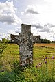 Hans Krok's cross
 -
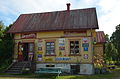 Dunbodi General Store Museum
 -
 Hesselby railway museum
 -
 Dalhem Church


.jpg)

References[edit]
- ^ "Småorternas landareal, folkmängd och invånare per km2 2005 och 2010, fortsättning" [Statistics area, population, 2005 and 2010] (PDF). www.scb.se. Statistics Sweden. p. 23. Retrieved 27 June 2015.
- ^ "Gotland i siffror" [Gotland in numbers]. www.gotland.se. Gotland Municipality. Archived from the original on 30 January 2018. Retrieved 27 June 2015.
- ^ The exact extent of the socken, now district, can be obtained by clicking on Kartinställningar and check the Socken box in the menu of this map from the Swedish National Heritage Board database.
- ^ "Förordning om district" [Regulation of districts] (PDF). Ministry of Finance. 17 June 2015. Retrieved 24 May 2016.
- ^ Lagerlöf, Erland; Svahnström, Gunnar (1973). Gotlands kyrkor [Gotland's Churches] (in Swedish). Stockholm: Rabén & Sjögren. pp. 116–119. ISBN 91-29-41035-5. SELIBR 7232718.
- ^ "Dalhem". www.ne.se. Nationalencyklopedin. Retrieved 27 May 2016.
- ^ Molin, Maria. "Gotländska primörer firas hela helgen" [Gotland's first vegetables celebrated during the weekend]. www.gotland.net. Gotlands Media AB. Retrieved 27 June 2015.
- ^ "Ridskolor" [Equestrian centers]. www.ridskolor.org. Ridskolor.org. Retrieved 27 June 2015.
- ^ "Församlingar på Gotland". www.svenskakyrkan.se. Church of Sweden. Retrieved 12 January 2019.
- ^ "Visby stifts indelning 2018". www.svenskakyrkan.se. Church of Sweden. Archived from the original on 12 January 2019. Retrieved 12 January 2019.
- ^ Molin, Malin. "Nostalgimuseum fångar atmosfären i en lanthandel" [Nostalgia museum captures the atmosphere of an old shop]. www.gotland.net. Gotlands Media AB. Retrieved 27 June 2015.
- ^ Svensson, Anders. "Slite- Roma 1902, 33 km". www.gotlandstaget.se. Gotland Train Association. Archived from the original on 29 June 2016. Retrieved 27 June 2015.
- ^ Molin, Maria. "En resa bakåt i tiden med Gotlandståget". www.gotland.net. Gotlands Media AB. Retrieved 27 June 2015.
External links[edit]

| Authority control databases: Artists |
|---|
This article about a location in Gotland County, Sweden is a stub. You can help Wikipedia by expanding it. |