
East Toronto

East Toronto is a former municipality, located within the current boundaries of Toronto, Ontario, Canada. It covered much of the present-day neighbourhood of the Upper Beaches, stretching up to Danforth Avenue in the north, part of it stretching to Lake Ontario in the south a portion of the present-day neighbourhood, The Beaches. The central street in East Toronto was Main Street, running between Danforth Avenue to Kingston Road. The commercial center of the town was located at the intersection of Main Street and Lake View Avenue (present-day Gerrard Street).[1][2] Following the annexation of East Toronto into Toronto, Main Street retained its name despite Toronto's conceptual Main Street being historically designated to be Yonge Street.
History[edit]
The area, after being colonized by British settlers, was occupied in about 1850, when it was a considerable distance from the city of Toronto. It was incorporated as a village in 1888 when about 800 people were living in the area. The area began to grow rapidly and in 1903 it was elevated from a village to a town. The southern part of the community by the lake became one of Toronto's most popular travel destinations and became home to hotels and amusement parks. The northern section, by contrast, was an industrial centre, home to the Grand Trunk Railway's main yards.[1] These facilities stretched along most of Gerrard Street and employed several hundred workers.[citation needed]
When East Toronto was annexed to city of Toronto in 1908 it had a population of about 5,000 people.[3] The CN freight yards closed down in that same year of 1908 and relocated to Belleville and Etobicoke, a move that forced the area into a transition from a railway-based small town into a commuter-based neighbourhood within a city. The trunk yards themselves were essentially abandoned for over 90 years until a housing development was built on most of the land they once occupied[1]
Today East Toronto commonly refers to the area east of the Don River. This includes neighbourhoods such as Upper Beaches, Riverdale, Leslieville, East Danforth, and the Beaches.[citation needed]
Street name changes[edit]
With the annexation by the city of Toronto in 1908, many East Toronto street names were changed, as the city of Toronto already had streets by those names. The following tables show the changes made, with the names of changed streets in bold text.
North/south streets[edit]
| Street names | |
|---|---|
| Pre-annexation | Present |
| Oak Avenue | Willow Avenue |
| Beach Avenue | Beech Avenue |
| Balsam Avenue | Balsam Avenue |
| Spruce Avenue | Spruce Hill Road |
| Howard Avenue | MacLean Avenue (between Lake Front and Queen only) |
| Catherine Street | Pickering Street |
| Hannaford Street | Hannaford Street |
| Charles Street | Malvern Avenue |
| John Street | Wayland Avenue |
| Edward Street | Osborne Avenue |
| Walter Street | Walter Street |
| Mary Street | Kimberley Avenue |
| Main Street | Main Street |
| Enderby Road | Enderby Road |
| Norwood Road | Norwood Road |
| Lee Avenue | Lee Avenue |
| Woodlee Road | Woodlee Road |
| Elliot Street | Barrington Avenue |
| Donald Street | Westlake Avenue (south of The Danforth only) |
| Morton Road | Morton Road |
The following north/south streets were outside the village limits of East Toronto, but were included in the annexation, and had their street names changed.
| Street names | |
|---|---|
| Pre-annexation | Present |
| Birch Avenue | Silver Birch Avenue |
| Maple Avenue | Scarborough Road (between Queen and Kingston only) |
| Cockburn Avenue | Scarborough Road (between Swanwick and Gerrard only) |
| Reid Avenue | Rhodes Avenue |
| Erie Terrace | Craven Road |
| Morley Avenue | Woodfield Road |
East/west streets[edit]
| Street names | |
|---|---|
| Pre-annexation | Present |
| Queen Street | Queen Street East |
| Cedar Avenue | Cedar Avenue |
| Pine Avenue | Pine Avenue |
| Kingston Road | Kingston Road |
| Lyall Avenue | Lyall Avenue |
| Benlamond Avenue | Benlamond Avenue |
| Swanwick Avenue | Swanwick Avenue (between Enderby and Pickering only) |
| Lake View Avenue | Gerrard Street East |
| Stephenson Avenue | Stephenson Avenue |
| Danforth Avenue | Danforth Avenue |
| Lansdowne Avenue | Coleman Avenue |
The following east/west streets were outside the village limits of East Toronto, but were included in the annexation. Streets that had their names changed are in bold text.
| Street names | |
|---|---|
| Pre-annexation | Present |
| Glenfern Avenue | Glenfern Avenue |
| Balmy Avenue | Balmy Avenue |
| Barwick Avenue | Swanwick Avenue (between Lawlor and Scarborough only) |
References[edit]
- ^ a b c
Ron Brown (2013). Rails Across Ontario: Exploring Ontario's Railway Heritage. Dundurn Press. p. 19. ISBN 9781459707542. Retrieved 2014-02-20.
Many wonder why there is a "Main Street" in Toronto's east end. This too came about when the GT selected a tract of land to create another sea of railway sidings. While it named its yard "York," the town that grew nearby was incorporated as "East Toronto" and the commercial main street became "Main Street."
- ^
Edward Relph (2014). Toronto: Transformations in A City and its Region. University of Pennsylvania. Retrieved 2014-02-20.
The names of many of the old municipalities have been preserved in business improvement areas, and, for example, Main Street subway station refers to the main street of East Toronto.
- ^
Mike Filey (2008). Toronto: The Way We Were. Dundurn Press. p. 209. ISBN 9781550028423. Retrieved 2014-02-20.
The request was approved and came into effect on January 1, 1888. The newly incorporated Village of East Toronto initially had a population of about 800, with that number increasing dramatically over the next few years, thanks in great measure to the presence of nearby railway yards. In 1903 the village became a town, a status it held until December 15, 1908, when, with a population of 4,800, the Town of East Toronto vanished into the history books to become part of the City of Toronto's Ward One.
External links[edit]
- Filey, Mike "Why Our Main Street is Nowhere Near the Centre of the City." Toronto Sun, January 15, 2006
- A History Tour of the Beach
- East Toronto - From little village, thriving town, to a part of Beaches heritage
- Early Maps of the Area
-
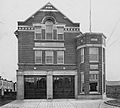 East Toronto Fire Station, 1911
 -
 East Toronto Police Station, 1911

