
Etterbeek
Etterbeek | |
|---|---|
 Etterbeek town hall | |
 Flag  Coat of arms | |
Location of Etterbeek  | |
| Country | |
| Community | Flemish Community French Community |
| Region | Brussels-Capital |
| Arrondissement | Brussels |
| Government | |
| • Mayor | Vincent De Wolf (MR) |
| Area | |
| • Total | 3.17 km2 (1.22 sq mi) |
| Population (2020-01-01)[1] | |
| • Total | 48,473 |
| • Density | 15,000/km2 (40,000/sq mi) |
| Postal codes | 1040 |
| NIS code | 21005 |
| Area codes | 02 |
| Website | www.etterbeek.be |
Etterbeek (French: [ɛtəʁˈbek]; Dutch: [ˈɛtərˌbeːk] ) is one of the nineteen municipalities located in the Brussels-Capital Region of Belgium. It neighbours the municipalities of the City of Brussels, Ixelles, Auderghem, Woluwe-Saint-Pierre, Woluwe-Saint-Lambert and Schaerbeek.
The main university campus of Vrije Universiteit Brussel is called Campus Etterbeek, although it is geographically not within Etterbeek but in the adjacent municipality of Ixelles.
History
Origins and etymology
According to legend, Gertrude, daughter of Pippin of Landen, founded a chapel here in the 8th century. A document by Otto I, dated 966, mentions the church of Iatrebache. The name Ietrebecca – possibly from the Celtic root ett meaning "rapid movement" and the Dutch word beek meaning "stream" – is found for the first time in a document dated 1127. The current spelling appears eleven years later in 1138, around which time a newer and larger church was built.
Middle Ages
In the Middle Ages, Etterbeek was a rural hamlet mostly independent of Brussels, aside from taxation rights on beer given to Brussels around 1300 by John II, Duke of Brabant. The following two centuries counted several grievous moments: in 1489, Albert, Duke of Saxe ravaged Etterbeek in his pursuit of the rebels who fought against Maximilian of Austria; in 1580, the village is destroyed once more, this time by the iconoclasts during the Protestant Reformation wars. Peace came back under the reigns of Archdukes Albert and Isabella.
Barony and municipality
In 1673, Etterbeek gained its independence from neighbouring Sint-Genesius-Rode, when Charles II of Spain promoted it into a barony. The first baron was Don Diego-Henriquez de Castro, general treasurer of the Netherlands armies. The Castro house was sold in 1767 and can still be seen today as Etterbeek's oldest building.
Under the French regime, Etterbeek was made into a commune, within the canton of Sint-Stevens-Woluwe. From then on, and especially after the Belgian Revolution of 1830 and the development of Brussels as a capital city, the population of Etterbeek grew quickly. In 1876, there were more than 10,000 inhabitants, in 1900 more than 20,000, and in 1910 more than 33,000. In the 1900s (decade), under the reign of Leopold II, construction boomed and changed the town's character with the addition of the broad avenues and residential areas that we know today.
Places of interest
- Two Roman Catholic churches are located in Etterbeek (Saint-Antoine or Sint-Antonius church and Notre-Dame-du-Sacré-Coeur). A third one (Sainte-Gertrude or Sint-Gertrude church) was destroyed in the 1990s as it threatened to collapse.
- The Fondation René Carcan, a foundation and museum in René Carcan's old studio, was located in Etterbeek.
- The Cauchie house was built in 1905 by Art Nouveau architect, painter and designer Paul Cauchie. Its façade is remarkable for its allegorical sgraffiti.
- Of a completely different character, the Barony dates from 1680 and is the oldest building in town.
- The "Avenue de la Chasse/Jachtlaan" features since 27 September 2014 a series of large scale Le Chat drawings by the Belgian Cartoonist Philippe Geluck, who was born and raised in this neighborhood. There are in total 24 drawings, for a total length of 120m.[2]
- Etterbeek has a few green areas, including the Jean-Felix Hap garden. The better known Cinquantenaire park lies on the territory of both the City of Brussels and Etterbeek. Park Leopold borders the municipality's territory.
-
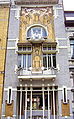 Art Nouveau Cauchie house, with sgraffiti
 -
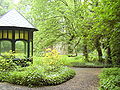 Jean Felix Hap garden
 -
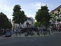 Place Jourdan
 -
 Mayor Vincent de Wolf in 2007


Transportation

There is a rail station called Gare d'Etterbeek or Etterbeek-Station but, like the Vrije Universiteit Brussel, it is also located in Ixelles or Elsene. Presently, Etterbeek has one rail station (Mérode) and three metro stations (Mérode, Thieffry and Pétillon).
Sports
- Etterbeek hosts two football clubs (R.R.C. Etterbeek and Armenia) playing in Belgian Provincial leagues at the Guy Thys stadium, named after the famous Belgian manager in summer 2003. He led Belgium national football team to fourth place at the 1986 FIFA World Cup.
- In the summer of 1996, the municipal swimming pool burnt down. It has now been rebuilt and is again open to the public.
Proposed redevelopment "Les Jardins de la Chasse"
A project is currently proposed to redevelop an area of Etterbeek near the Avenue des Casernes. This project would result in the town hall and police station being relocated to new buildings in a central administrative centre on this site.[3] The new site is being called the Jardins de la Chasse (French) or Tuinen van de Jacht (Dutch).
Events

Etterbeek hosts an annual medieval market. Previously held at the end of May on the Avenue du 2ème Régiment de Lanciers in the south of the municipality, in recent years it has taken place in Cinquantenaire.
Notable residents
Born in Etterbeek:
- Jérôme d'Ambrosio, racing driver (born 1985)
- Jean Brachet, biochemist (1909–1998)
- Monique De Wael a.k.a. Misha Defonseca (1937) writer of Misha: A Mémoire of the Holocaust Years
- Pierre Deligne, Fields Medal-winning mathematician (born 1944)
- François Englert, Nobel Prize–winning physicist (born 1932)
- Giani Esposito (1930–1974), actor
- Lara Fabian, international singer (born 1970)
- Marouane Fellaini, football player (born 1987)
- Philippe Francq, comic book artist (born 1961)
- André Franquin, cartoonist, creator of Gaston and the Marsupilami (1924–1997)
- Philippe Geluck, comics writer and artist, creator of Le Chat (born 1954)[4]
- Georges Grün, football defender (born 1962)
- Georges Remi a.k.a. Hergé, comics writer and artist, creator of The Adventures of Tintin (1907–1983)
- Arthur Maurice Hocart, anthropologist (1883–1939)
- Daniel Hulet, cartoonist (1942–2011)
- Roland Lethem, filmmaker and writer (born 1942)
- Alexandre de Merode, member of the International Olympic Committee (IOC) (1934–2002)
- Constantin Meunier, painter and sculptor (1831–1905)
- Amélie Nothomb, writer (born 1966)
- Charles Picqué, politician, freemason, and mayor of Saint-Gilles (born 1948)
- Godelieve Quisthoudt-Rowohl, German politician (born 1947)
- Richard Makela a.k.a. Monsieur R, rap artist (born 1975)
- Herman Van Rompuy, politician (born in 1947) and first permanent President of the European Council
- Stromae, singer (born in 1985)
Lived part of their life in Etterbeek:
- Jean Absil, composer and organist (1893–1974)
- Jean-Baptiste Baronian, Belgian-Armenian writer (born 1942)
- René Carcan, engraver and sculptor (1925–1993)
- Adrien de Gerlache, officer of the Belgian Navy and leader of the Belgian Antarctic Expedition (1866–1934)
- W.F. Hermans, Dutch writer (1921–1995)
- Edgar Pierre Jacobs, comic book artist, creator of Blake and Mortimer (1904–1987)
Buried in Etterbeek:
- Moise Tshombe, a Congolese politician
International relations
Etterbeek is twinned with:
References
- ^ "Bevolking per gemeente op 1 januari 2020". Statbel.
- ^ "Journal La Vie Etterbeekoise Octobre 2014" (pdf) (in French).
- ^ "Les Jardins de la Chasse" (pdf) (in French). Retrieved 12 October 2008.
- ^ "Journal La Vie Etterbeekoise Octobre 2014" (pdf) (in French).
External links
- Official website of Etterbeek, in French and Dutch
Places adjacent to Etterbeek | |
|---|---|
