
File:Nova Scotia topographic map.png
Size of this preview: 734 × 599 pixels. Other resolutions: 294 × 240 pixels | 588 × 480 pixels | 940 × 768 pixels | 1,254 × 1,024 pixels | 1,342 × 1,096 pixels.
Original file (1,342 × 1,096 pixels, file size: 1.21 MB, MIME type: image/png)
| This is a file from the Wikimedia Commons. Information from its description page there is shown below. Commons is a freely licensed media file repository. You can help. |
Summary
| Description |
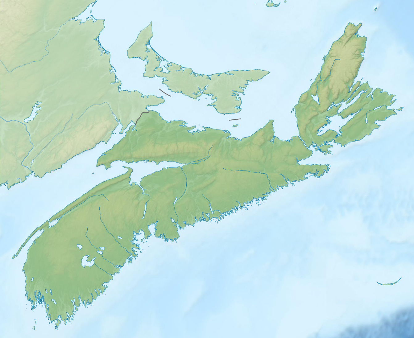
English: Topographic location map of Nova Scotia, Canada
Equirectangular projection, N/S stretching 145 %. Geographic limits of the map:
|
| Date | |
| Source | File:Carte topographique des Provinces Maritimes du Canada.svg |
| Author | Sémhur, GrandEscogriffe |
| Other versions |
|


Licensing
This file is licensed under the Creative Commons Attribution-Share Alike 4.0 International license.
- You are free:
- to share – to copy, distribute and transmit the work
- to remix – to adapt the work
- Under the following conditions:
- attribution – You must give appropriate credit, provide a link to the license, and indicate if changes were made. You may do so in any reasonable manner, but not in any way that suggests the licensor endorses you or your use.
- share alike – If you remix, transform, or build upon the material, you must distribute your contributions under the same or compatible license as the original.
File history
Click on a date/time to view the file as it appeared at that time.
| Date/Time | Thumbnail | Dimensions | User | Comment | |
|---|---|---|---|---|---|
| current | 19:38, 22 March 2022 | | 1,342 × 1,096 (1.21 MB) | GrandEscogriffe | Uploaded a work by Sémhur GrandEscogriffe from File:Carte topographique des Provinces Maritimes du Canada.svg with UploadWizard |
File usage
More than 100 pages use this file. The following list shows the first 100 pages that use this file only. A full list is available.
- Albro Lake
- Anderson Lake (Nova Scotia)
- Ash Lake (Hubley)
- Ash Lake (Timberlea)
- Ash Lake (Wellington)
- Baptizing Lake (Nova Scotia)
- Bay of Fundy
- Bayers Lake
- Bear Lake (Halifax Regional Municipality, Nova Scotia)
- Beaver Lake (Inverness)
- Beaver Lake (Victoria, Nova Scotia)
- Belle Lake (Nova Scotia)
- Blacketts Lake
- Boot Lake (Nova Scotia)
- Bras d'Or Lake
- Buchanan Lake (Nova Scotia)
- Cape Breton Highlands
- Cape Breton Highlands National Park
- Cape Dauphin
- Carter Lake (Nova Scotia)
- Catcha Lake
- Centre 200
- Chocolate Lake
- Chéticamp Flowage
- Cobequid Bay
- Dean Lake (Annapolis)
- East Bay Hills (Nova Scotia)
- Enchanted Lake
- Ferguson Lake (Nova Scotia)
- First Lake (Richmond County, Nova Scotia)
- Folly Lake (Annapolis County)
- Fox Lake (Devon)
- Fox Lake (Goffs)
- Fox Lake (Timberlea)
- Frenchman Lake (Nova Scotia)
- Frog Lake (Nova Scotia)
- Gaspereau Lake
- Golden Lake (Nova Scotia)
- Indian Harbour Lake, Nova Scotia
- Ingonish
- Jack Lake (Halifax)
- Kejimikujik Lake
- Kejimkujik National Park
- Kidston Lake
- LaHave River
- Lake Ainslie
- Lake Banook
- Lake Charles (Nova Scotia)
- Lake Charlotte, Nova Scotia
- Lake Major, Nova Scotia
- Lake Micmac
- Lake Rossignol
- Little Albro Lake
- Little Cranberry Lake (Annapolis)
- Little Cranberry Lake (Halifax)
- Loch Lomond (Cape Breton)
- Lovett Lake
- MacMullin Lake
- MacPherson Lake
- Maynard Lake (Nova Scotia)
- McDonald Lake (Nova Scotia)
- McMillan Flowage
- Medway River (Nova Scotia)
- Mersey River (Nova Scotia)
- Middle Lake (Nova Scotia)
- Minas Basin
- Mira River (Nova Scotia)
- Morris Lake (Nova Scotia)
- Nelson Lake (Halifax)
- New Glasgow, Nova Scotia
- North Lake (Nova Scotia)
- Perry Lake (Nova Scotia)
- Petite Rivière (Lunenburg County)
- Porcupine Lake (Nova Scotia)
- Porters Lake, Nova Scotia
- Queensland, Nova Scotia
- Russell Lake (Nova Scotia)
- Sackville River
- Scotiabank Centre
- Sgurra Bhreac (Nova Scotia)
- Shelburne River
- Shubenacadie Grand Lake
- Six Mile Lake (Nova Scotia)
- South Lake (Antigonish)
- South Lake (Halifax)
- South Lake (Victoria)
- Springfield Lake
- St. Mary's River (Nova Scotia)
- Sullivan's Pond
- Sullivan Lake (Halifax)
- Tangier Grand Lake
- Tomahawk Lake (Halifax)
- Waterford Lake
- Webber Lake (Eastern Shore)
- Webber Lake (Sackville)
- White Hill (Nova Scotia)
- Williams Lake (Goffs)
- Williams Lake (Halifax)
- Williams Lake (Jeddore)
- Willis Lake (Richmond)
View more links to this file.
Global file usage
The following other wikis use this file:
- Usage on ban.wikipedia.org
- Usage on es.wikipedia.org
- Bahía de Fundy
- Plantilla:Mapa de localización de Nueva Escocia
- Wikiproyecto:Ilustración/Taller de Cartografía/Realizaciones/América del Norte
- Cabo Chignecto
- Bahía de Chignecto
- Istmo de Chignecto
- Península de Nueva Escocia
- Islas Tusket
- Estrecho de Canso
- Estrecho de Northumberland
- Puerto Parrsboro
- Reserva del parque nacional de la Isla Sable
- Usage on fr.wikipedia.org
- Île du Cap-Breton
- Baie de Fundy
- Détroit de Canso
- Île de Sable (Canada)
- Baie de Chignectou
- Siège de Louisbourg (1758)
- Parc national des Hautes-Terres-du-Cap-Breton
- Parc national de Kejimkujik
- Isthme de Chignectou
- Île Georges
- Île Oak
- Vallée d'Annapolis
- Bassin des Mines
- Falaises fossilifères de Joggins
- Baie Sainte-Marie
- Île Janvrin
- Montagne Noire (Nouvelle-Écosse)
- Lac de Chéticamp
- Aire sauvage de Polletts Cove-Aspy Fault
- Parc provincial de Cape Smokey
- Parc provincial Cabot's Landing
- Canal de Saint-Pierre
- Lac Bras d'Or
- Aire sauvage Tobeatic
- Modèle:Géolocalisation/Nouvelle-Écosse
- Montain des Écureaux
- Pain de Sucre (Nouvelle-Écosse)
- Réserve nationale de faune de l'Île Sea Wolf
- Cap Peirce (Canada)
- Parc provincial Le Fourneau
- Île Boularderie
- Lac Company
- Île au Phoque
- Cap de Sable
- Colline White
- Cap Split
View more global usage of this file.