
Formentera
 Flag of Formentera | |
 Satellite view (2006) | |
 Formentera  Formentera | |
| Geography | |
|---|---|
| Location | Mediterranean Sea |
| Coordinates | 38°42′N 1°27′E / 38.700°N 1.450°E |
| Archipelago | Pityuses, Balearic Islands |
| Area | 83.24 km2 (32.14 sq mi) |
| Highest elevation | 119 m (390 ft) |
| Highest point | La Mola |
| Administration | |
| Autonomous community | Balearic Islands |
| Largest settlement | Sant Francesc Xavier |
| Government | Island Council of Formentera |
| President | Lorenzo Córdoba (Independent) |
| Demographics | |
| Population | 11,389 (Estimate 1 January 2023) |
| Pop. density | 136.8/km2 (354.3/sq mi) |
| Additional information | |
| Official languages: Catalan, Spanish | |
.svg)
Formentera (Catalan pronunciation: [furmənˈteɾə], Spanish: [foɾmenˈteɾa]) is a Spanish island located in the Mediterranean Sea, which belongs to the Balearic Islands autonomous community (Spain) together with Mallorca, Menorca, and Ibiza.
Formentera is the smallest and most southerly island of the Pityusic Islands group (comprising Ibiza and Formentera itself, as well as various small islets). It covers an area of 83.24 square kilometres (32.14 sq mi), including offshore islets. At the 2011 Census, the population was 10,583; according to the Census of 1 January 2021,[1] it counted 11,891 inhabitants, while the official estimate as at 1 January 2023 was 11,389.[2]
History[edit]
The island's name is said to derive from the Latin word frumentarium, meaning "granary". The island was occupied in prehistoric times, going back to 2,000–1,600 BC. Archaeological sites from that period remain in Ca na Costa,[3] Cap de Barbaria (multiple sites)[4] and Cova des Fum.[5] The island had been occupied by the Carthaginians before passing to the ancient Romans. In succeeding centuries, it passed to the Visigoths, the Byzantines, the Vandals, and the Arabs. In 1109 it was the target of a devastating attack by the Norwegian king Sigurd I at the head of the "Norwegian Crusade". The island was conquered by James I the Conqueror, added to the Crown of Aragon and later became part of the medieval Kingdom of Majorca.
From 1403 to the early 18th century, the threat of Barbary pirate attacks rendered the island uninhabitable.[6][7] On 17 June 1651, during the Franco-Spanish War (1635–1659), a squadron of Spanish galleys under John of Austria the Younger captured the French galleon Lion Couronné off this island.
The island and its surrounding islets became a separate insular council with the same territory as the eponymous municipality after 1977. Before that, it was administered in the former insular council of Ibiza and Formentera (covering the whole group of the Pityusic Islands), but in a separate comarca which already covered the current municipality of Formentera. This reform allowed Ibiza to unify its comarca of five municipalities with its new insular council, no longer administrating Formentera.
Geography[edit]


The main island of Formentera is 19 kilometres (12 mi) long and is located about 6 kilometres (4 mi) south of Ibiza in the Mediterranean Sea. More specifically Formentera is part of the delimitation of the Balearic Sea, which is a northwestern element of the Mediterranean Sea.[8] Its major villages are Sant Francesc Xavier, Sant Ferran de ses Roques, El Pilar de la Mola (on the La Mola peninsula), La Savina, and Es Pujols, the most important tourist destination of the island.
Formentera comprises one municipality, also called Formentera, and has a population of 11,981 (as of 1 January 2021). Its land area is 83.24 km2 (32.14 sq mi). It is subdivided into several civil parishes (parròquies), themselves subdivided into vendas (véndes in Catalan).
North of Formentera is located Espalmador (in Catalan: Illa de S'Espalmador), the second largest island of the Pitiusas Islands, surrounded by a few minor islets.
Espalmador is a tombolo, separated from the main island of Formentera by a shallow sandbar. This area is a popular stopping point for those in yachts heading between Ibiza and Formentera.
Climate[edit]
Formentera has a semi-arid climate with hot, very dry summers and warm, dry winters. The flat orography of the island means that rainfall is scarce and the temperature is quite uniform. The average annual rainfall is 370–420 mm. The average annual temperature is between 17 and 18 °C. Overall, the climate is mild, with an average annual temperature of 18.6 degrees Celsius and 2883 hours of annual sunshine on average.
| Climate data for Formentera 119m amsl | |||||||||||||
|---|---|---|---|---|---|---|---|---|---|---|---|---|---|
| Month | Jan | Feb | Mar | Apr | May | Jun | Jul | Aug | Sep | Oct | Nov | Dec | Year |
| Mean daily maximum °C (°F) | 15 (59) |
16 (61) |
17 (63) |
19 (66) |
22 (72) |
26 (79) |
29 (84) |
30 (86) |
28 (82) |
24 (75) |
19 (66) |
16 (61) |
22 (71) |
| Daily mean °C (°F) | 12 (54) |
12 (54) |
13 (55) |
15 (59) |
18 (64) |
22 (72) |
25 (77) |
26 (79) |
24 (75) |
20 (68) |
16 (61) |
13 (55) |
18 (64) |
| Mean daily minimum °C (°F) | 8 (46) |
8 (46) |
9 (48) |
11 (52) |
14 (57) |
17 (63) |
21 (70) |
21 (70) |
19 (66) |
16 (61) |
12 (54) |
9 (48) |
14 (57) |
| Average precipitation mm (inches) | 35 (1.4) |
30 (1.2) |
40 (1.6) |
35 (1.4) |
25 (1.0) |
15 (0.6) |
5 (0.2) |
25 (1.0) |
40 (1.6) |
65 (2.6) |
50 (2.0) |
55 (2.2) |
420 (16.8) |
| Average precipitation days | 6 | 5 | 6 | 6 | 5 | 3 | 1 | 3 | 4 | 5 | 6 | 6 | 56 |
| Source: Climates to travel[9] | |||||||||||||
Administration[edit]
Insular government[edit]
Elections are held every four years concurrently with local elections. From 1983 to 2007, councilors were indirectly elected from the results of the election to Parliament of the Balearic Islands for the constituencies of Ibiza and Formentera (then forming a single Island council, with Formentera sending a single councilor to both Parliament and the Island council). Since 2007, however, separate direct elections are held to elect the Island Council of Formentera, with currently 17 seats (it only sends a single one to the Balearic Parliament).
Results of the elections to the former Island Council of Ibiza and Formentera[edit]
Island Councilors of the Island Council of Ibiza and Formentera between 1978 and 2007 | ||||||
|---|---|---|---|---|---|---|
| Election | Distribution | President | ||||
| 1979[10] |
|
Cosme Vidal Juan (ICIF–CD, CP) | ||||
| 1983 |
|
|||||
| 1987 |
|
Antoni Marí (PP) | ||||
| 1991 |
| |||||
| 1995 |
| |||||
| 1999 |
|
Pilar Costa (Pacte Progressista) | ||||
| 2003 |
|
Pere Palau (PP) | ||||
| Split into the Island Councils of Ibiza and Formentera respectively, with the 2007 Amendment of the Statue of Autonomy coming into effect. | ||||||
Results of the elections to the Island Council of Formentera[edit]
Island Councilors of the Island Council of Formentera since 2007 | |||||||
|---|---|---|---|---|---|---|---|
| Election | Distribution | President | |||||
| 2007 |
|
Jaume Ferrer Ribas (GxF) | |||||
| 2011 |
| ||||||
| 2015 |
| ||||||
| 2019 |
|
Alejandra Ferrer (GxF) (2019-2021) | |||||
| Ana Juan (PSIB–PSOE) (2021-2023) | |||||||
| 2023 |
|
Lorenzo Córdoba (Sa Unió, Independent) | |||||
Attractions[edit]
Since the 1960s, Formentera has been a popular destination for hippies.[11] Formentera is renowned across Europe for many pristine white beaches and the fact that nude sunbathing is allowed on most of its beaches.[12]
Throughout its history, Formentera has been the subject of many legends, written in novels by famous writers such as Jules Verne, and in songs by musicians as varied as Gilberto Gil and Pink Floyd. From this artistic curiosity, the annual Formentera Jazz Festival has been held annually in early June and features many emerging and established musicians from the local and international scene.[13]
The Canadian writer Patrick Roscoe was born in Formentera.[14] Joni Mitchell wrote her 1971 album Blue on the island while Bob Dylan once slept on the Far de la Mola on the island.[15] Author Matt Haig also writes about visiting the island often in his twenties in Reasons to Stay Alive.[15] The opening track of the King Crimson album Islands, Formentera Lady, is named after the island. James Taylor also worked on his hit song Carolina in My Mind on holiday from recording with Apple Records, though he began writing it in London and completed it on the nearby island of Ibiza.[16]
The Cap de Barbaria Lighthouse plays a pivotal role in Julio Medem's 2001 Spanish film, Sex and Lucia (Lucía y el sexo), which was filmed on the island and served as a touchstone for the various characters' interwoven relationships.[17][18]
Although paved roads allow access to all parts of the island and cars are easily hired in the port, many people choose to rent mopeds or even bicycles due to the flat nature of most of the island and the availability of dedicated cycle tracks in many locations.
The island also has four Martello towers.[19]
Transport[edit]
With no airports, the island was formerly reachable only by boat from Ibiza, making it the quieter of the two islands, but in recent years regular passenger service from the Spanish mainland has increased tourism.
Ferry tickets from Ibiza are available in advance, as are transfers from Ibiza airport or port directly to accommodation in Formentera.
Ferries to Formentera operate from their own terminal in Ibiza port, with departures every half hour in high season on large (200+ passenger) fast catamarans. The journey takes approximately 30 minutes comprising 10 minutes leaving Ibiza, 10 minutes crossing the sea, and 10 minutes arriving in Formentera past the isthmus to Espalmador.
Some of the anchorages may not be suitable for sailboats under less than ideal circumstances.[20]
Culture[edit]
A local Ibizan (eivissenc) variant of the Balearic dialect of the Catalan language is spoken in Formentera. While the official languages are Catalan and Spanish, other major languages like English, Italian, German, French and Dutch can also be heard extensively in the summer due to mass tourism.
Sports[edit]
From 1 September to 7 September, Formentera hosted the 2007 Techno 293 OD World Championships in windsurfing for juniors under 15 and youths under 17.[21]
Villages[edit]
Gallery[edit]
-
 Church in Sant Francesc
 -
 Satellite picture of Formentera
 -
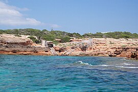 The coastline near Cala Saona
 -
 Island of Espalmador
 -
 Trucadors Beach


References[edit]
- ^ Instituto Nacional de Estadística, Madrid, 2021.
- ^ Instituto Nacional de Estadística, Madrid, 2023.
- ^ Ca na Costa, L’Enciclopèdia d’Eivissa i Formentera, http://www.eeif.es/veus/Costa-ca-na/, accessed 16/04/2017.
- ^ Cap de Barbaria, L’Enciclopèdia d’Eivissa i Formentera, http://www.eeif.es/veus/Barbaria-cap-de/, accessed 16/04/2017.
- ^ Cova des Fum, L’Enciclopèdia d’Eivissa i Formentera, http://www.eeif.es/veus/Fum-cova-des/, accessed 16/04/2017.
- ^ Bryant, Sue (June 2007). Ibiza and Formentera. New Holland Publishers. ISBN 9781845378141.[permanent dead link]
- ^ Syed, Muzaffar Husain; Akhtar, Syed Saud; Usmani, B. D. (14 September 2011). Concise History of Islam. Vij Books India Pvt Ltd. ISBN 9789382573470.
- ^ C.Michael Hogan. 2011. Balearic Sea. Encyclopedia of Earth. Eds. P. Saundry & C.J.Cleveland. National Council for Science and the Environment. Washington DC
- ^ "Formentera Climate". Climates to travel. Retrieved 20 October 2018.
- ^ Martín Rotger Lebrón (2021). "Les eleccions preautonòmiques de 1979 a les Illes Balears". Mayurqa (in Spanish). 3: 107–121. doi:10.22307/2386.7124.2021.01.008.
- ^ Stewart, James (18 June 2010). "Formentera: where the party's still chilled". The Guardian. Retrieved 15 June 2015.
- ^ Mischke, Roland; Schwarz, Berthold (2001). Ibiza, Formentera. Nelles Verlag. pp. 91–. ISBN 978-3-88618-768-3.
- ^ "Formentera Jazz Festival". formenterajazzfestival.info. Retrieved 21 March 2023.
- ^ Burton, Peter (2003). Death Comes Easy: The Gay Times Book of Murder Stories. London, U.K.: Gay Men's Press. p. 458. ISBN 9781902852461. OCLC 58997265.
- ^ a b Haig, Matt (2015). Reasons to Stay Alive. London, U.K.: Cannongate Books. p. 231. ISBN 9781782116820.
Bob Dylan spent some time living in the lighthouse at Cap de Barbaria, on the island's southern tip. Formentera was also where Joni Mitchell wrote the album Blue.
- ^ Halperin, Ian (2003). Fire and Rain: The James Taylor Story (Revised ed.). Citadel Press. p. 71. ISBN 0-8065-2348-4.
- ^ "Far Del Cap de Barbaria". Illes Balears Film Commission. Retrieved 21 March 2023.
- ^ Basté, Jordi (9 August 2014). "Tras los pasos de 'Lucía y el sexo´en Formentera". La Vanguardia.
- ^ Clements, Bill; Clements, William H. (2011). Martello Towers Worldwide. Casemate Publishers. p. 56. ISBN 9781848845350. Retrieved 5 March 2015.
- ^ "El temporal empuja contra las rocas a un velero con la tripulación dentro en Formentera [Vídeo]". 10 April 2019.
- ^ Techno 293 OD World Championships
External links[edit]
Comarcas of the Balearic Islands | ||
|---|---|---|
| International | |
|---|---|
| National | |
| Geographic | |