
Hậu Giang province
Hậu Giang | |
|---|---|
 Asia Clock Tower in the centre of Vị Thanh city | |
 Seal | |
 Location of Hậu Giang in Vietnam | |
 | |
| Coordinates: 9°47′N 105°28′E / 9.783°N 105.467°E | |
| Country | |
| Region | Mekong Delta |
| Capital | Vị Thanh |
| Government | |
| • People's Council Chair | Trần Văn Huyến |
| • People's Committee Chair | Đồng Văn Thanh |
| Area | |
• Total | 1,622.23 km2 (626.35 sq mi) |
| Population (2023) | |
• Total | 1,028,300 |
| • Density | 630/km2 (1,600/sq mi) |
| Demographics | |
| • Ethnicities | Vietnamese, Hoa, Chăm, Khmer |
| GDP[2] | |
| • Total | VND 29.763 trillion US$ 1.293 billion |
| Time zone | UTC+7 (ICT) |
| Area codes | 293 |
| ISO 3166 code | VN-73 |
| HDI (2020) | (41th) |
| Website | www |
Hậu Giang is a province located in the Mekong Delta region in the southern part of Vietnam. Vị Thanh is the capital.
History
[edit].svG)

Until the end of the Vietnam War in 1975, the province included the city of Cần Thơ which was the provincial capital. In 1975, the province was renamed Cần Thơ province, with the city of Cần Thơ still the capital. In late 2004, Cần Thơ and some surrounding cities became Cần Thơ municipality (Thành Phố Cần Thơ). The remainder of Cần Thơ province became Hậu Giang province.
Hậu Giang has an industrial zone of 902 ha. There are 120 km of national roads: National Highway 61 (which leads to National Highway 1, going through Cần Thơ Municipality on the Hậu River to Ho Chi Minh City), and water connections by canal and river to the Hậu River.
An estimated 80% of the province will be underwater following a 0.5 metres (1 ft 8 in) sea level rise relative to the current land elevation, which is subsiding over time.[4]
Administrative divisions
[edit]Hậu Giang is subdivided into eight district-level sub-divisions:
- 5 districts:
They are further subdivided into 11 commune-level towns (or townships), 51 communes, and 13 wards.
Gallery
[edit]-
 In the Chương Thiện Victory Monument in Ward 5, Vi Thanh city.
 -
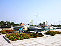
 Clock Tower in the center of Vị Thanh City.
 -
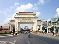 The welcome gate of Hậu Giang province, located in the town of Cái Tắc.
 -
 On National Highway 61, the section passing Cái Tắc town market.
 -
 Lung Ngoc Hoang Nature Reserve


References
[edit]- ^ Biểu số 4.6: Hiện trạng sử dụng đất vùng Đồng Bằng Sông Cửu Long năm 2022 [Table 4.6: Current land use status in the Mekong Delta in 2022] (PDF) (Decision 3048/QĐ-BTNMT) (in Vietnamese). Ministry of Natural Resources and Environment (Vietnam). 18 October 2023. – the data in the report are in hectares, rounded to integers
- ^ "Tình hình kinh tế, xã hội Hậu Giang năm 2018" (PDF). UBND tỉnh Hậu Giang. Retrieved 10 May 2020.[permanent dead link]
- ^ "Human Development Index by province(*) by Cities, provincies and Year". General Statistics Office of Vietnam. Retrieved September 28, 2024.
- ^ Minderhoud, P. S. J.; Coumou, L.; Erkens, G.; Middelkoop, H.; Stouthamer, E. (2019). "Mekong delta much lower than previously assumed in sea-level rise impact assessments". Nature Communications. 10 (1): 3847. doi:10.1038/s41467-019-11602-1. ISSN 2041-1723. PMC 6713785. PMID 31462638.
External links
[edit]Places adjacent to Hậu Giang province | ||||||||||||||||
|---|---|---|---|---|---|---|---|---|---|---|---|---|---|---|---|---|
| ||||||||||||||||
| International | |
|---|---|
| National | |
| Geographic | |
This article about a location in Hậu Giang Province, Vietnam is a stub. You can help Wikipedia by expanding it. |